Ormea geodata
Ormea (Piedmont) is a seat of a third-order administrative division; located in Italy in Europe/Rome (GMT+2) time zone. With population of 1,276 people, there are 5710 cities with bigger population in this country. Compared to other cities in Italy, 53.2% of cities are located further ↑North; 94.5% of cities are located further →East and 89% of cities have lower elevation than Ormea. Note1


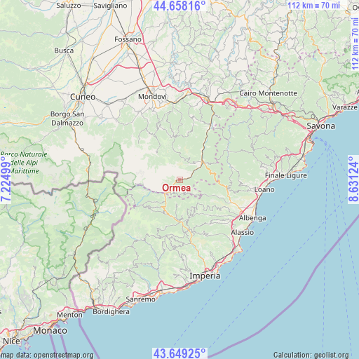
Ormea GPS coordinates[2]
44° 9' 21.096" North, 7° 55' 41.196" East
| Map corner | latitude | longitude |
|---|---|---|
| Upper-left | 44.65816°, | 7.22499° |
| Center: | 44.15586°, | 7.92811° |
| Lower-right: | 43.64925°, | 8.63124° |
| Map W x H: | 112.2×112.2 km | = 69.7×69.7mi |
| max Lat: | 47.04031° ⇑53.2% North |
| Ormea: | 44.15586° |
| min Lat: | ⇓46.8% South 35.50142° |
| min Long | Ormea | max Long |
| 6.69888° | 7.92811° | 18.48682° |
| W 5.5%⇐ | ⇒94.5% E |
Elevation
Elevation of Ormea is 695 m = 2280 ft, and this is 388.3 m = 1274 ft above average elevation for this country.
| Max E: |
2085 m = 6841 ft | 11% |
| Ormea | 695 m 2280 ft | |
| Avg. | 306.7 m = 1006 ft | |
Min E: |
-4 m = -13 ft | 89% |
See also: Italy elevation on elevation.city.
Geographical zone
Ormea is located in North temperate zone (between Tropic of Cancer and the Arctic Circle). Distance of this Northern Tropic circle is 2303.8 km =1431.5 mi to South.| Distance of | km | miles | from Ormea |
|---|---|---|---|
| North Pole | 5097.4 | 3167.4 | to North |
| Arctic Circle | 2491.5 | 1548.1 | to North |
| Tropic Cancer | 2303.8 | 1431.5 | to South |
| Equator | 4909.7 | 3050.7 | to South |


Nearby cities:
15 places around Ormea: (largest is in red/bold)
• Alto
7.9 km =4.9 mi,  131°
131°
• Aquila di Arroscia
9.9 km =6.2 mi,  141°
141°
• Armo
7.6 km =4.7 mi,  187°
187°
• Borghetto d'Arroscia
11.8 km =7.3 mi,  159°
159°
• Borgo di Ranzo
12.7 km =7.9 mi,  147°
147°
• Caprauna
4.9 km =3 mi, 154°
• Castelbianco
12.6 km =7.8 mi,  111°
111°
• Cosio di Arroscia
11.6 km =7.2 mi,  221°
221°
• Garessio
9.1 km =5.7 mi,  51°
51°
• Mendatica
13.1 km =8.1 mi,  228°
228°
• Nasino-Borgo
9.5 km =5.9 mi,  119°
119°
• Pieve di Teco
12.1 km =7.5 mi,  184°
184°
• Pornassio
10.6 km =6.6 mi,  206°
206°
• Priola
12.4 km =7.7 mi,  36°
36°
• Vessalico
12.5 km =7.8 mi,  168°
168°
Sources, notices
• [Note1] Compared only with cities in Italy existing in our database
• [Src1] Map data: © OpenStreetMap contributors (CC-BY-SA)
• [Src2] Other city data from geonames.org with taken over terms of usage.
• [Src3] Geographical zone / Annual Mean Temperature by Robert A. Rohde @ Wikipedia
