Priola geodata
Priola (Piedmont) is a seat of a third-order administrative division; located in Italy in Europe/Rome (GMT+2) time zone. With population of 245 people, there are 10916 cities with bigger population in this country. Compared to other cities in Italy, 52.3% of cities are located further ↑North; 93.3% of cities are located further →East and 81.7% of cities have lower elevation than Priola. Note1


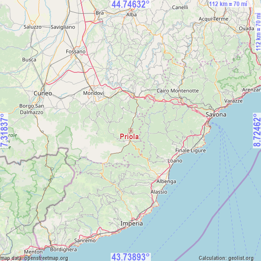
Priola GPS coordinates[2]
44° 14' 41.208" North, 8° 1' 17.364" East
| Map corner | latitude | longitude |
|---|---|---|
| Upper-left | 44.74632°, | 7.31837° |
| Center: | 44.24478°, | 8.02149° |
| Lower-right: | 43.73893°, | 8.72462° |
| Map W x H: | 112×112 km | = 69.6×69.6mi |
| max Lat: | 47.04031° ⇑52.3% North |
| Priola: | 44.24478° |
| min Lat: | ⇓47.7% South 35.50142° |
| min Long | Priola | max Long |
| 6.69888° | 8.02149° | 18.48682° |
| W 6.7%⇐ | ⇒93.3% E |
Elevation
Elevation of Priola is 548 m = 1798 ft, and this is 241.3 m = 792 ft above average elevation for this country.
| Max E: |
2085 m = 6841 ft | 18.3% |
| Priola | 548 m 1798 ft | |
| Avg. | 306.7 m = 1006 ft | |
Min E: |
-4 m = -13 ft | 81.7% |
See also: Italy elevation on elevation.city.
Geographical zone
Priola is located in North temperate zone (between Tropic of Cancer and the Arctic Circle). Distance of this Northern Tropic circle is 2313.6 km =1437.6 mi to South.| Distance of | km | miles | from Priola |
|---|---|---|---|
| North Pole | 5087.5 | 3161.2 | to North |
| Arctic Circle | 2481.6 | 1542 | to North |
| Tropic Cancer | 2313.6 | 1437.6 | to South |
| Equator | 4919.6 | 3056.9 | to South |


Nearby cities:
15 places around Priola: (largest is in red/bold)
• Bagnasco
6.9 km =4.3 mi,  15°
15°
• Bardineto
10.9 km =6.8 mi,  124°
124°
• Battifollo
8.4 km =5.2 mi,  354°
354°
• Calizzano
7.8 km =4.8 mi,  97°
97°
• Garessio
4.2 km =2.6 mi,  184°
184°
• Lisio
7.7 km =4.8 mi,  333°
333°
• Massimino
7.3 km =4.5 mi,  33°
33°
• Monasterolo Casotto
11.2 km =7 mi, 326°
• Nucetto
11 km =6.8 mi, 16°
• Ormea
12.4 km =7.7 mi,  216°
216°
• Pamparato
9.2 km =5.7 mi,  292°
292°
• Perlo
10.9 km =6.8 mi, 27°
• Roburent
12.4 km =7.7 mi,  303°
303°
• Scagnello
10.2 km =6.3 mi,  344°
344°
• Viola
6.8 km =4.2 mi,  318°
318°
Sources, notices
• [Note1] Compared only with cities in Italy existing in our database
• [Src1] Map data: © OpenStreetMap contributors (CC-BY-SA)
• [Src2] Other city data from geonames.org with taken over terms of usage.
• [Src3] Geographical zone / Annual Mean Temperature by Robert A. Rohde @ Wikipedia
