Borgo di Ranzo geodata
Borgo di Ranzo (Liguria) is a seat of a third-order administrative division; located in Italy in Europe/Rome (GMT+2) time zone. With population of 219 people, there are 11038 cities with bigger population in this country. Compared to other cities in Italy, 54.1% of cities are located further ↑North; 93.4% of cities are located further →East and 65.8% of cities have higher elevation than Borgo di Ranzo. Note1


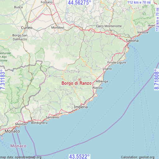
Borgo di Ranzo GPS coordinates[2]
44° 3' 34.668" North, 8° 0' 53.82" East
| Map corner | latitude | longitude |
|---|---|---|
| Upper-left | 44.56275°, | 7.31183° |
| Center: | 44.05963°, | 8.01495° |
| Lower-right: | 43.5522°, | 8.71808° |
| Map W x H: | 112.4×112.4 km | = 69.8×69.8mi |
| max Lat: | 47.04031° ⇑54.1% North |
| Borgo di Ranzo: | 44.05963° |
| min Lat: | ⇓45.9% South 35.50142° |
| min Long | Borgo di Ranzo | max Long |
| 6.69888° | 8.01495° | 18.48682° |
| W 6.6%⇐ | ⇒93.4% E |
Elevation
Elevation of Borgo di Ranzo is 122 m = 400 ft, and this is 184.7 m = 606 ft below average elevation for this country.
| Max E: |
2085 m = 6841 ft | 65.8% |
| Avg. | 306.7 m = 1006 ft | |
| Borgo di Ranzo | 122 m = 400 ft | |
Min E: |
-4 m = -13 ft | 34.2% |
See also: Italy elevation on elevation.city.
Geographical zone
Borgo di Ranzo is located in North temperate zone (between Tropic of Cancer and the Arctic Circle). Distance of this Northern Tropic circle is 2293.1 km =1424.9 mi to South.| Distance of | km | miles | from Borgo di Ranzo |
|---|---|---|---|
| North Pole | 5108.1 | 3174 | to North |
| Arctic Circle | 2502.2 | 1554.8 | to North |
| Tropic Cancer | 2293.1 | 1424.9 | to South |
| Equator | 4899 | 3044.1 | to South |


Nearby cities:
15 places around Borgo di Ranzo: (largest is in red/bold)
• Alto
5.5 km =3.4 mi,  349°
349°
• Aquila di Arroscia
3 km =1.9 mi, 345°
• Borghetto d'Arroscia
2.8 km =1.7 mi,  263°
263°
• Casanova Lerrone
4 km =2.5 mi,  139°
139°
• Castelbianco
7.7 km =4.8 mi,  38°
38°
• Cesio
6.6 km =4.1 mi,  209°
209°
• Garlenda
7.1 km =4.4 mi,  114°
114°
• Nasino-Borgo
6.2 km =3.9 mi,  12°
12°
• Onzo
3.2 km =2 mi,  68°
68°
• Ortovero
6.8 km =4.2 mi,  95°
95°
• Rossi
7.5 km =4.7 mi,  151°
151°
• Stellanello
7.6 km =4.7 mi, 151°
• Testico
6.1 km =3.8 mi,  171°
171°
• Vendone
4.9 km =3 mi, 66°
• Vessalico
4.7 km =2.9 mi,  250°
250°
Sources, notices
• [Note1] Compared only with cities in Italy existing in our database
• [Src1] Map data: © OpenStreetMap contributors (CC-BY-SA)
• [Src2] Other city data from geonames.org with taken over terms of usage.
• [Src3] Geographical zone / Annual Mean Temperature by Robert A. Rohde @ Wikipedia
