Vessalico geodata
Vessalico (Liguria) is a seat of a third-order administrative division; located in Italy in Europe/Rome (GMT+2) time zone. With population of 225 people, there are 11003 cities with bigger population in this country. Compared to other cities in Italy, 54.3% of cities are located further ↑North; 94% of cities are located further →East and 56.4% of cities have higher elevation than Vessalico. Note1


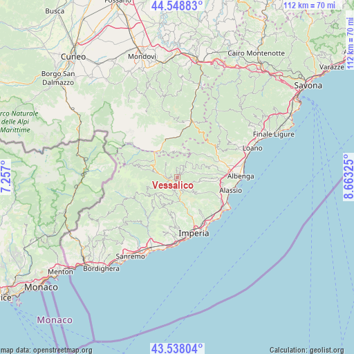
Vessalico GPS coordinates[2]
44° 2' 44.124" North, 7° 57' 36.468" East
| Map corner | latitude | longitude |
|---|---|---|
| Upper-left | 44.54883°, | 7.257° |
| Center: | 44.04559°, | 7.96013° |
| Lower-right: | 43.53804°, | 8.66325° |
| Map W x H: | 112.4×112.4 km | = 69.8×69.8mi |
| max Lat: | 47.04031° ⇑54.3% North |
| Vessalico: | 44.04559° |
| min Lat: | ⇓45.7% South 35.50142° |
| min Long | Vessalico | max Long |
| 6.69888° | 7.96013° | 18.48682° |
| W 6%⇐ | ⇒94% E |
Elevation
Elevation of Vessalico is 192 m = 630 ft, and this is 114.7 m = 376 ft below average elevation for this country.
| Max E: |
2085 m = 6841 ft | 56.4% |
| Avg. | 306.7 m = 1006 ft | |
| Vessalico | 192 m = 630 ft | |
Min E: |
-4 m = -13 ft | 43.6% |
See also: Italy elevation on elevation.city.
Geographical zone
Vessalico is located in North temperate zone (between Tropic of Cancer and the Arctic Circle). Distance of this Northern Tropic circle is 2291.5 km =1423.9 mi to South.| Distance of | km | miles | from Vessalico |
|---|---|---|---|
| North Pole | 5109.7 | 3175 | to North |
| Arctic Circle | 2503.8 | 1555.8 | to North |
| Tropic Cancer | 2291.5 | 1423.9 | to South |
| Equator | 4897.4 | 3043.1 | to South |


Nearby cities:
15 places around Vessalico: (largest is in red/bold)
• Alto
7.8 km =4.8 mi,  25°
25°
• Aquila di Arroscia
5.8 km =3.6 mi,  38°
38°
• Armo
5.9 km =3.7 mi,  322°
322°
• Aurigo
7.6 km =4.7 mi,  202°
202°
• Borghetto d'Arroscia
2.1 km =1.3 mi,  53°
53°
• Borgo di Ranzo
4.7 km =2.9 mi,  70°
70°
• Caprauna
7.8 km =4.8 mi,  356°
356°
• Caravonica
5.8 km =3.6 mi,  181°
181°
• Casanova Lerrone
7.1 km =4.4 mi,  102°
102°
• Cesio
4.3 km =2.7 mi,  163°
163°
• Onzo
7.9 km =4.9 mi, 69°
• Pieve di Teco
3.6 km =2.2 mi,  272°
272°
• Pornassio
7.8 km =4.8 mi,  290°
290°
• Rezzo
7.6 km =4.7 mi,  248°
248°
• Testico
6.9 km =4.3 mi,  130°
130°
Sources, notices
• [Note1] Compared only with cities in Italy existing in our database
• [Src1] Map data: © OpenStreetMap contributors (CC-BY-SA)
• [Src2] Other city data from geonames.org with taken over terms of usage.
• [Src3] Geographical zone / Annual Mean Temperature by Robert A. Rohde @ Wikipedia
