Oldenico geodata
Oldenico (Piedmont) is a seat of a third-order administrative division; located in Italy in Europe/Rome (GMT+2) time zone. With population of 221 people, there are 11027 cities with bigger population in this country. Compared to other cities in Italy, 70.3% of cities are located further ↓South; 89.3% of cities are located further →East and 62.8% of cities have higher elevation than Oldenico. Note1


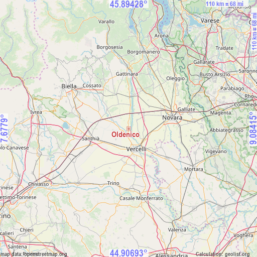
Oldenico GPS coordinates[2]
45° 24' 9.936" North, 8° 22' 51.708" East
| Map corner | latitude | longitude |
|---|---|---|
| Upper-left | 45.89428°, | 7.6779° |
| Center: | 45.40276°, | 8.38103° |
| Lower-right: | 44.90693°, | 9.08415° |
| Map W x H: | 109.8×109.8 km | = 68.2×68.2mi |
| max Lat: | 47.04031° ⇑29.7% North |
| Oldenico: | 45.40276° |
| min Lat: | ⇓70.3% South 35.50142° |
| min Long | Oldenico | max Long |
| 6.69888° | 8.38103° | 18.48682° |
| W 10.7%⇐ | ⇒89.3% E |
Elevation
Elevation of Oldenico is 143 m = 469 ft, and this is 163.7 m = 537 ft below average elevation for this country.
| Max E: |
2085 m = 6841 ft | 62.8% |
| Avg. | 306.7 m = 1006 ft | |
| Oldenico | 143 m = 469 ft | |
Min E: |
-4 m = -13 ft | 37.2% |
See also: Italy elevation on elevation.city.
Geographical zone
Oldenico is located in North temperate zone (between Tropic of Cancer and the Arctic Circle). Distance of this North polar circle is 2352.9 km =1462 mi to North.| Distance of | km | miles | from Oldenico |
|---|---|---|---|
| North Pole | 4958.7 | 3081.2 | to North |
| Arctic Circle | 2352.9 | 1462 | to North |
| Tropic Cancer | 2442.4 | 1517.6 | to South |
| Equator | 5048.3 | 3136.9 | to South |


Nearby cities:
15 places around Oldenico: (largest is in red/bold)
• Albano Vercellese
2.6 km =1.6 mi,  359°
359°
• Borgo Vercelli
8.3 km =5.2 mi,  128°
128°
• Caresanablot
5.1 km =3.2 mi,  170°
170°
• Casalbeltrame
7.7 km =4.8 mi,  59°
59°
• Casalvolone
6.5 km =4 mi,  93°
93°
• Casanova Elvo
6.8 km =4.2 mi,  267°
267°
• Collobiano
2.7 km =1.7 mi,  255°
255°
• Formigliana
7.6 km =4.7 mi,  292°
292°
• Greggio
5.4 km =3.4 mi,  3°
3°
• Olcenengo
7.1 km =4.4 mi,  231°
231°
• Quinto Vercellese
3 km =1.9 mi,  209°
209°
• Recetto
7.6 km =4.7 mi,  33°
33°
• San Nazzaro Sesia
5.2 km =3.2 mi,  41°
41°
• Villarboit
5.2 km =3.2 mi,  318°
318°
• Villata
4.4 km =2.7 mi,  114°
114°
Sources, notices
• [Note1] Compared only with cities in Italy existing in our database
• [Src1] Map data: © OpenStreetMap contributors (CC-BY-SA)
• [Src2] Other city data from geonames.org with taken over terms of usage.
• [Src3] Geographical zone / Annual Mean Temperature by Robert A. Rohde @ Wikipedia
