Villarboit geodata
Villarboit (Piedmont) is a seat of a third-order administrative division; located in Italy in Europe/Rome (GMT+2) time zone. With population of 295 people, there are 10693 cities with bigger population in this country. Compared to other cities in Italy, 71.5% of cities are located further ↓South; 89.7% of cities are located further →East and 60% of cities have higher elevation than Villarboit. Note1


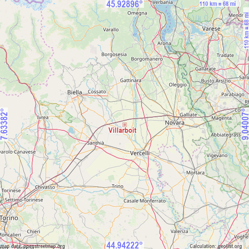
Villarboit GPS coordinates[2]
45° 26' 15.9" North, 8° 20' 12.984" East
| Map corner | latitude | longitude |
|---|---|---|
| Upper-left | 45.92896°, | 7.63382° |
| Center: | 45.43775°, | 8.33694° |
| Lower-right: | 44.94222°, | 9.04007° |
| Map W x H: | 109.7×109.7 km | = 68.2×68.2mi |
| max Lat: | 47.04031° ⇑28.5% North |
| Villarboit: | 45.43775° |
| min Lat: | ⇓71.5% South 35.50142° |
| min Long | Villarboit | max Long |
| 6.69888° | 8.33694° | 18.48682° |
| W 10.3%⇐ | ⇒89.7% E |
Elevation
Elevation of Villarboit is 163 m = 535 ft, and this is 143.7 m = 471 ft below average elevation for this country.
| Max E: |
2085 m = 6841 ft | 60% |
| Avg. | 306.7 m = 1006 ft | |
| Villarboit | 163 m = 535 ft | |
Min E: |
-4 m = -13 ft | 40% |
See also: Italy elevation on elevation.city.
Geographical zone
Villarboit is located in North temperate zone (between Tropic of Cancer and the Arctic Circle). Distance of this North polar circle is 2349 km =1459.6 mi to North.| Distance of | km | miles | from Villarboit |
|---|---|---|---|
| North Pole | 4954.9 | 3078.8 | to North |
| Arctic Circle | 2349 | 1459.6 | to North |
| Tropic Cancer | 2446.3 | 1520.1 | to South |
| Equator | 5052.2 | 3139.3 | to South |


Nearby cities:
15 places around Villarboit: (largest is in red/bold)
• Albano Vercellese
3.7 km =2.3 mi,  110°
110°
• Arborio
7.6 km =4.7 mi,  31°
31°
• Balocco
4.8 km =3 mi,  294°
294°
• Buronzo
7.3 km =4.5 mi,  310°
310°
• Casanova Elvo
5.3 km =3.3 mi,  218°
218°
• Collobiano
4.6 km =2.9 mi,  169°
169°
• Formigliana
3.6 km =2.2 mi,  254°
254°
• Greggio
4 km =2.5 mi,  67°
67°
• Landiona
9.4 km =5.8 mi,  45°
45°
• Olcenengo
8.5 km =5.3 mi,  194°
194°
• Oldenico
5.2 km =3.2 mi,  138°
138°
• Quinto Vercellese
6.8 km =4.2 mi,  163°
163°
• Recetto
8 km =5 mi, 72°
• San Giacomo Vercellese
6.8 km =4.2 mi,  353°
353°
• San Nazzaro Sesia
6.9 km =4.3 mi,  89°
89°
Sources, notices
• [Note1] Compared only with cities in Italy existing in our database
• [Src1] Map data: © OpenStreetMap contributors (CC-BY-SA)
• [Src2] Other city data from geonames.org with taken over terms of usage.
• [Src3] Geographical zone / Annual Mean Temperature by Robert A. Rohde @ Wikipedia
