Formigliana geodata
Formigliana (Piedmont) is a seat of a third-order administrative division; located in Italy in Europe/Rome (GMT+2) time zone. With population of 371 people, there are 10388 cities with bigger population in this country. Compared to other cities in Italy, 71.2% of cities are located further ↓South; 90.2% of cities are located further →East and 60% of cities have higher elevation than Formigliana. Note1


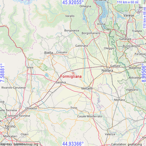
Formigliana GPS coordinates[2]
45° 25' 45.336" North, 8° 17' 30.948" East
| Map corner | latitude | longitude |
|---|---|---|
| Upper-left | 45.92055°, | 7.58881° |
| Center: | 45.42926°, | 8.29193° |
| Lower-right: | 44.93366°, | 8.99506° |
| Map W x H: | 109.7×109.7 km | = 68.2×68.2mi |
| max Lat: | 47.04031° ⇑28.8% North |
| Formigliana: | 45.42926° |
| min Lat: | ⇓71.2% South 35.50142° |
| min Long | Formigliana | max Long |
| 6.69888° | 8.29193° | 18.48682° |
| W 9.8%⇐ | ⇒90.2% E |
Elevation
Elevation of Formigliana is 163 m = 535 ft, and this is 143.7 m = 471 ft below average elevation for this country.
| Max E: |
2085 m = 6841 ft | 60% |
| Avg. | 306.7 m = 1006 ft | |
| Formigliana | 163 m = 535 ft | |
Min E: |
-4 m = -13 ft | 40% |
See also: Italy elevation on elevation.city.
Geographical zone
Formigliana is located in North temperate zone (between Tropic of Cancer and the Arctic Circle). Distance of this North polar circle is 2349.9 km =1460.2 mi to North.| Distance of | km | miles | from Formigliana |
|---|---|---|---|
| North Pole | 4955.8 | 3079.4 | to North |
| Arctic Circle | 2349.9 | 1460.2 | to North |
| Tropic Cancer | 2445.3 | 1519.4 | to South |
| Equator | 5051.3 | 3138.7 | to South |


Nearby cities:
15 places around Formigliana: (largest is in red/bold)
• Albano Vercellese
7 km =4.3 mi,  92°
92°
• Balocco
3.1 km =1.9 mi,  343°
343°
• Buronzo
6 km =3.7 mi, 340°
• Carisio
7.5 km =4.7 mi,  253°
253°
• Casanova Elvo
3.2 km =2 mi,  176°
176°
• Collobiano
5.7 km =3.5 mi,  129°
129°
• Gifflenga
8.5 km =5.3 mi,  326°
326°
• Greggio
7.7 km =4.8 mi,  71°
71°
• Olcenengo
7.4 km =4.6 mi,  169°
169°
• Oldenico
7.6 km =4.7 mi,  112°
112°
• Quinto Vercellese
7.8 km =4.8 mi,  135°
135°
• San Germano Vercellese
9.4 km =5.8 mi,  201°
201°
• San Giacomo Vercellese
8.1 km =5 mi,  19°
19°
• Villanova Biellese
9.6 km =6 mi,  307°
307°
• Villarboit
3.6 km =2.2 mi, 74°
Sources, notices
• [Note1] Compared only with cities in Italy existing in our database
• [Src1] Map data: © OpenStreetMap contributors (CC-BY-SA)
• [Src2] Other city data from geonames.org with taken over terms of usage.
• [Src3] Geographical zone / Annual Mean Temperature by Robert A. Rohde @ Wikipedia
