Colonnella geodata
Colonnella (Abruzzo) is a seat of a third-order administrative division; located in Italy in Europe/Rome (GMT+2) time zone. With population of 1,179 people, there are 6029 cities with bigger population in this country. Compared to other cities in Italy, 64.2% of cities are located further ↑North; 77.2% of cities are located further ←West and 52.4% of cities have lower elevation than Colonnella. Note1


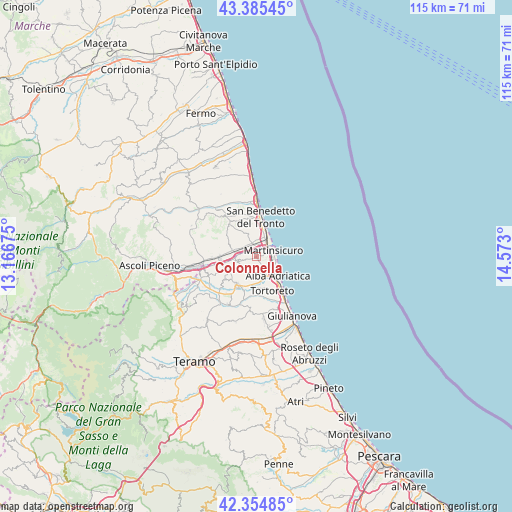
Colonnella GPS coordinates[2]
42° 52' 20.28" North, 13° 52' 11.532" East
| Map corner | latitude | longitude |
|---|---|---|
| Upper-left | 43.38545°, | 13.16675° |
| Center: | 42.8723°, | 13.86987° |
| Lower-right: | 42.35485°, | 14.573° |
| Map W x H: | 114.6×114.6 km | = 71.2×71.2mi |
| max Lat: | 47.04031° ⇑64.2% North |
| Colonnella: | 42.8723° |
| min Lat: | ⇓35.8% South 35.50142° |
| min Long | Colonnella | max Long |
| 6.69888° | 13.86987° | 18.48682° |
| W 77.2%⇐ | ⇒22.8% E |
Elevation
Elevation of Colonnella is 249 m = 817 ft, and this is 57.7 m = 189 ft below average elevation for this country.
| Max E: |
2085 m = 6841 ft | 47.6% |
| Avg. | 306.7 m = 1006 ft | |
| Colonnella | 249 m = 817 ft | |
Min E: |
-4 m = -13 ft | 52.4% |
See also: Italy elevation on elevation.city.
Geographical zone
Colonnella is located in North temperate zone (between Tropic of Cancer and the Arctic Circle). Distance of this Northern Tropic circle is 2161 km =1342.8 mi to South.| Distance of | km | miles | from Colonnella |
|---|---|---|---|
| North Pole | 5240.1 | 3256 | to North |
| Arctic Circle | 2634.2 | 1636.8 | to North |
| Tropic Cancer | 2161 | 1342.8 | to South |
| Equator | 4767 | 2962.1 | to South |


Nearby cities:
15 places around Colonnella: (largest is in red/bold)
• Acquaviva Picena
8.5 km =5.3 mi,  332°
332°
• Alba Adriatica
6.4 km =4 mi,  134°
134°
• Centobuchi
3.1 km =1.9 mi, 325°
• Controguerra
4.7 km =2.9 mi,  244°
244°
• Corropoli
5.8 km =3.6 mi,  209°
209°
• Martinsicuro
3.6 km =2.2 mi,  75°
75°
• Monsampolo del Tronto
6.8 km =4.2 mi,  294°
294°
• Monteprandone
5.9 km =3.7 mi, 334°
• Nereto
7.5 km =4.7 mi, 212°
• Pagliare
8.2 km =5.1 mi,  267°
267°
• San Giovanni
1.7 km =1.1 mi,  11°
11°
• Spinetoli
8.8 km =5.5 mi,  282°
282°
• Stella
5.2 km =3.2 mi, 288°
• Tortoreto
8.4 km =5.2 mi,  155°
155°
• Villa Rosa
4.8 km =3 mi,  120°
120°
Sources, notices
• [Note1] Compared only with cities in Italy existing in our database
• [Src1] Map data: © OpenStreetMap contributors (CC-BY-SA)
• [Src2] Other city data from geonames.org with taken over terms of usage.
• [Src3] Geographical zone / Annual Mean Temperature by Robert A. Rohde @ Wikipedia
