Controguerra geodata
Controguerra (Abruzzo) is a seat of a third-order administrative division; located in Italy in Europe/Rome (GMT+2) time zone. With population of 1,063 people, there are 6430 cities with bigger population in this country. Compared to other cities in Italy, 64.3% of cities are located further ↑North; 76.8% of cities are located further ←West and 53% of cities have lower elevation than Controguerra. Note1


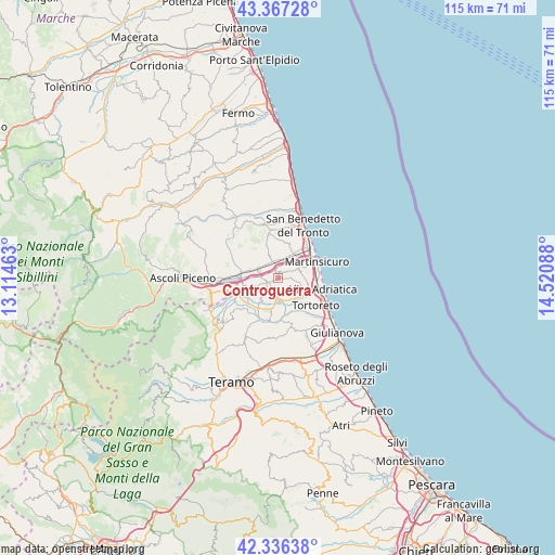
Controguerra GPS coordinates[2]
42° 51' 14.328" North, 13° 49' 3.9" East
| Map corner | latitude | longitude |
|---|---|---|
| Upper-left | 43.36728°, | 13.11463° |
| Center: | 42.85398°, | 13.81775° |
| Lower-right: | 42.33638°, | 14.52088° |
| Map W x H: | 114.6×114.6 km | = 71.2×71.2mi |
| max Lat: | 47.04031° ⇑64.3% North |
| Controguerra: | 42.85398° |
| min Lat: | ⇓35.7% South 35.50142° |
| min Long | Controguerra | max Long |
| 6.69888° | 13.81775° | 18.48682° |
| W 76.8%⇐ | ⇒23.2% E |
Elevation
Elevation of Controguerra is 253 m = 830 ft, and this is 53.7 m = 176 ft below average elevation for this country.
| Max E: |
2085 m = 6841 ft | 47% |
| Avg. | 306.7 m = 1006 ft | |
| Controguerra | 253 m = 830 ft | |
Min E: |
-4 m = -13 ft | 53% |
See also: Italy elevation on elevation.city.
Geographical zone
Controguerra is located in North temperate zone (between Tropic of Cancer and the Arctic Circle). Distance of this Northern Tropic circle is 2159 km =1341.5 mi to South.| Distance of | km | miles | from Controguerra |
|---|---|---|---|
| North Pole | 5242.1 | 3257.3 | to North |
| Arctic Circle | 2636.3 | 1638.1 | to North |
| Tropic Cancer | 2159 | 1341.5 | to South |
| Equator | 4764.9 | 2960.8 | to South |


Nearby cities:
15 places around Controguerra: (largest is in red/bold)
• Ancarano
6.1 km =3.8 mi,  252°
252°
• Centobuchi
5.2 km =3.2 mi,  28°
28°
• Colli del Tronto
6.3 km =3.9 mi,  293°
293°
• Colonnella
4.7 km =2.9 mi,  64°
64°
• Corropoli
3.3 km =2.1 mi,  155°
155°
• Monsampolo del Tronto
5.2 km =3.2 mi,  337°
337°
• Nereto
4.3 km =2.7 mi,  177°
177°
• Pagliare
4.3 km =2.7 mi, 292°
• San Giovanni
5.9 km =3.7 mi,  51°
51°
• San Silvestro
7.4 km =4.6 mi,  281°
281°
• Sant'Omero
7.5 km =4.7 mi,  198°
198°
• Spinetoli
5.9 km =3.7 mi,  312°
312°
• Stella
3.7 km =2.3 mi,  349°
349°
• Torano Nuovo
4.8 km =3 mi,  223°
223°
• Villa San Giuseppe
6.2 km =3.9 mi, 285°
Sources, notices
• [Note1] Compared only with cities in Italy existing in our database
• [Src1] Map data: © OpenStreetMap contributors (CC-BY-SA)
• [Src2] Other city data from geonames.org with taken over terms of usage.
• [Src3] Geographical zone / Annual Mean Temperature by Robert A. Rohde @ Wikipedia
