Erve geodata
Erve (Lombardy) is a seat of a third-order administrative division; located in Italy in Europe/Rome (GMT+2) time zone. With population of 740 people, there are 8021 cities with bigger population in this country. Compared to other cities in Italy, 86.8% of cities are located further ↓South; 73.8% of cities are located further →East and 83.2% of cities have lower elevation than Erve. Note1


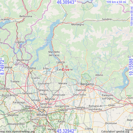
Erve GPS coordinates[2]
45° 49' 17.688" North, 9° 27' 10.26" East
| Map corner | latitude | longitude |
|---|---|---|
| Upper-left | 46.30943°, | 8.74972° |
| Center: | 45.82158°, | 9.45285° |
| Lower-right: | 45.32942°, | 10.15598° |
| Map W x H: | 109×109 km | = 67.7×67.7mi |
| max Lat: | 47.04031° ⇑13.2% North |
| Erve: | 45.82158° |
| min Lat: | ⇓86.8% South 35.50142° |
| min Long | Erve | max Long |
| 6.69888° | 9.45285° | 18.48682° |
| W 26.2%⇐ | ⇒73.8% E |
Elevation
Elevation of Erve is 575 m = 1886 ft, and this is 268.3 m = 880 ft above average elevation for this country.
| Max E: |
2085 m = 6841 ft | 16.8% |
| Erve | 575 m 1886 ft | |
| Avg. | 306.7 m = 1006 ft | |
Min E: |
-4 m = -13 ft | 83.2% |
See also: Italy elevation on elevation.city.
Geographical zone
Erve is located in North temperate zone (between Tropic of Cancer and the Arctic Circle). Distance of this North polar circle is 2306.3 km =1433.1 mi to North.| Distance of | km | miles | from Erve |
|---|---|---|---|
| North Pole | 4912.2 | 3052.3 | to North |
| Arctic Circle | 2306.3 | 1433.1 | to North |
| Tropic Cancer | 2489 | 1546.6 | to South |
| Equator | 5094.9 | 3165.8 | to South |


Nearby cities:
15 places around Erve: (largest is in red/bold)
• Brumano
5.2 km =3.2 mi,  45°
45°
• Calchera-Frontale
4.8 km =3 mi,  72°
72°
• Calolziocorte
3.1 km =1.9 mi,  202°
202°
• Carenno
2.4 km =1.5 mi,  160°
160°
• Costa Valle Imagna
4.5 km =2.8 mi,  117°
117°
• Favirano
4.4 km =2.7 mi,  178°
178°
• Galbiate
5.8 km =3.6 mi,  264°
264°
• Garlate
4.3 km =2.7 mi, 255°
• Monte Marenzo
5.5 km =3.4 mi, 178°
• Olginate
4.3 km =2.7 mi,  218°
218°
• Pescate
4.8 km =3 mi,  286°
286°
• Rota d'Imagna
4.7 km =2.9 mi,  77°
77°
• Torre de' Busi
5.7 km =3.5 mi, 158°
• Valgreghentino
5.6 km =3.5 mi,  212°
212°
• Vercurago
2.7 km =1.7 mi,  240°
240°
Sources, notices
• [Note1] Compared only with cities in Italy existing in our database
• [Src1] Map data: © OpenStreetMap contributors (CC-BY-SA)
• [Src2] Other city data from geonames.org with taken over terms of usage.
• [Src3] Geographical zone / Annual Mean Temperature by Robert A. Rohde @ Wikipedia
