Calchera-Frontale geodata
Calchera-Frontale (Lombardy) is a seat of a third-order administrative division; located in Italy in Europe/Rome (GMT+2) time zone. With population of 848 people, there are 7415 cities with bigger population in this country. Compared to other cities in Italy, 87.2% of cities are located further ↓South; 73.1% of cities are located further →East and 86.5% of cities have lower elevation than Calchera-Frontale. Note1


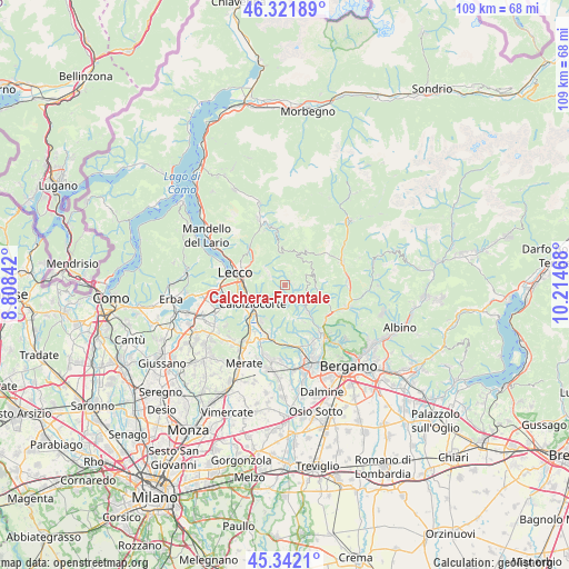
Calchera-Frontale GPS coordinates[2]
45° 50' 2.94" North, 9° 30' 41.58" East
| Map corner | latitude | longitude |
|---|---|---|
| Upper-left | 46.32189°, | 8.80842° |
| Center: | 45.83415°, | 9.51155° |
| Lower-right: | 45.3421°, | 10.21468° |
| Map W x H: | 108.9×108.9 km | = 67.7×67.7mi |
| max Lat: | 47.04031° ⇑12.8% North |
| Calchera-Frontale: | 45.83415° |
| min Lat: | ⇓87.2% South 35.50142° |
| min Long | Calchera-Fronta | max Long |
| 6.69888° | 9.51155° | 18.48682° |
| W 26.9%⇐ | ⇒73.1% E |
Elevation
Elevation of Calchera-Frontale is 643 m = 2110 ft, and this is 336.3 m = 1103 ft above average elevation for this country.
| Max E: |
2085 m = 6841 ft | 13.5% |
| Calchera-Frontale | 643 m 2110 ft | |
| Avg. | 306.7 m = 1006 ft | |
Min E: |
-4 m = -13 ft | 86.5% |
See also: Italy elevation on elevation.city.
Geographical zone
Calchera-Frontale is located in North temperate zone (between Tropic of Cancer and the Arctic Circle). Distance of this North polar circle is 2304.9 km =1432.2 mi to North.| Distance of | km | miles | from Calchera-Frontale |
|---|---|---|---|
| North Pole | 4910.8 | 3051.4 | to North |
| Arctic Circle | 2304.9 | 1432.2 | to North |
| Tropic Cancer | 2490.4 | 1547.5 | to South |
| Equator | 5096.3 | 3166.7 | to South |


Nearby cities:
15 places around Calchera-Frontale: (largest is in red/bold)
• Berbenno
5.1 km =3.2 mi,  115°
115°
• Blello
4.6 km =2.9 mi,  84°
84°
• Botta
1.6 km =1 mi,  97°
97°
• Brumano
2.4 km =1.5 mi,  339°
339°
• Carenno
5.2 km =3.2 mi,  226°
226°
• Corna Imagna
2.6 km =1.6 mi, 98°
• Costa Valle Imagna
3.5 km =2.2 mi,  189°
189°
• Erve
4.8 km =3 mi,  252°
252°
• Fuipiano Valle Imagna
2.6 km =1.6 mi,  30°
30°
• Gerosa
5 km =3.1 mi,  69°
69°
• Locatello
1.7 km =1.1 mi,  86°
86°
• Morterone
5.1 km =3.2 mi,  333°
333°
• Rota d'Imagna
0.4 km =0.2 mi,  171°
171°
• Sant'Omobono Terme
3.4 km =2.1 mi,  146°
146°
• Selino Basso
3.2 km =2 mi, 145°
Sources, notices
• [Note1] Compared only with cities in Italy existing in our database
• [Src1] Map data: © OpenStreetMap contributors (CC-BY-SA)
• [Src2] Other city data from geonames.org with taken over terms of usage.
• [Src3] Geographical zone / Annual Mean Temperature by Robert A. Rohde @ Wikipedia
