Morter geodata
Morter (Trentino-Alto Adige) is a populated place; located in Italy in Europe/Rome (GMT+2) time zone. With population of 659 people, there are 8563 cities with bigger population in this country. Compared to other cities in Italy, 98.9% of cities are located further ↓South; 59.5% of cities are located further →East and 89.8% of cities have lower elevation than Morter. Note1


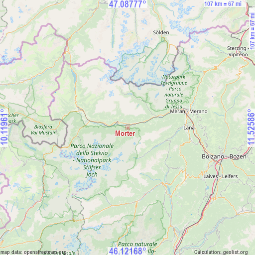
Morter GPS coordinates[2]
46° 36' 24.768" North, 10° 49' 21.828" East
| Map corner | latitude | longitude |
|---|---|---|
| Upper-left | 47.08777°, | 10.11961° |
| Center: | 46.60688°, | 10.82273° |
| Lower-right: | 46.12168°, | 11.52586° |
| Map W x H: | 107.4×107.4 km | = 66.7×66.7mi |
| max Lat: | 47.04031° ⇑1.1% North |
| Morter: | 46.60688° |
| min Lat: | ⇓98.9% South 35.50142° |
| min Long | Morter | max Long |
| 6.69888° | 10.82273° | 18.48682° |
| W 40.5%⇐ | ⇒59.5% E |
Elevation
Elevation of Morter is 715 m = 2346 ft, and this is 408.3 m = 1340 ft above average elevation for this country.
| Max E: |
2085 m = 6841 ft | 10.2% |
| Morter | 715 m 2346 ft | |
| Avg. | 306.7 m = 1006 ft | |
Min E: |
-4 m = -13 ft | 89.8% |
See also: Italy elevation on elevation.city.
Geographical zone
Morter is located in North temperate zone (between Tropic of Cancer and the Arctic Circle). Distance of this North polar circle is 2219 km =1378.8 mi to North.| Distance of | km | miles | from Morter |
|---|---|---|---|
| North Pole | 4824.9 | 2998.1 | to North |
| Arctic Circle | 2219 | 1378.8 | to North |
| Tropic Cancer | 2576.3 | 1600.8 | to South |
| Equator | 5182.2 | 3220.1 | to South |


Nearby cities:
15 places around Morter: (largest is in red/bold)
• Castelbello
6.9 km =4.3 mi,  69°
69°
• Castelbello-Ciardes - Kastelbell-Tschars
6.8 km =4.2 mi, 69°
• Certosa
12.8 km =8 mi,  31°
31°
• Ciardes
9.8 km =6.1 mi, 68°
• Coldrano
1.8 km =1.1 mi,  9°
9°
• Ganda
6.7 km =4.2 mi,  209°
209°
• Laces
2.8 km =1.7 mi, 68°
• Lasa
9.6 km =6 mi,  277°
277°
• Meiern
5.6 km =3.5 mi, 213°
• Naturno
14.4 km =8.9 mi, 71°
• Oris
13.7 km =8.5 mi, 280°
• Santa Valburga
15 km =9.3 mi,  115°
115°
• Senales
12.8 km =8 mi, 30°
• Silandro
4.8 km =3 mi,  299°
299°
• Tarres
4 km =2.5 mi,  90°
90°
Sources, notices
• [Note1] Compared only with cities in Italy existing in our database
• [Src1] Map data: © OpenStreetMap contributors (CC-BY-SA)
• [Src2] Other city data from geonames.org with taken over terms of usage.
• [Src3] Geographical zone / Annual Mean Temperature by Robert A. Rohde @ Wikipedia
