Silandro geodata
Silandro (Trentino-Alto Adige) is a seat of a third-order administrative division; located in Italy in Europe/Rome (GMT+2) time zone. With population of 4,517 people, there are 2137 cities with bigger population in this country. Compared to other cities in Italy, 99% of cities are located further ↓South; 60.1% of cities are located further →East and 90.9% of cities have lower elevation than Silandro. Note1


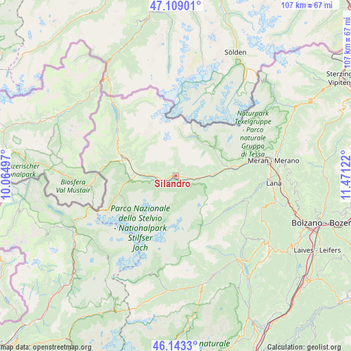
Silandro GPS coordinates[2]
46° 37' 41.916" North, 10° 46' 5.124" East
| Map corner | latitude | longitude |
|---|---|---|
| Upper-left | 47.10901°, | 10.06497° |
| Center: | 46.62831°, | 10.76809° |
| Lower-right: | 46.1433°, | 11.47122° |
| Map W x H: | 107.4×107.4 km | = 66.7×66.7mi |
| max Lat: | 47.04031° ⇑1% North |
| Silandro: | 46.62831° |
| min Lat: | ⇓99% South 35.50142° |
| min Long | Silandro | max Long |
| 6.69888° | 10.76809° | 18.48682° |
| W 39.9%⇐ | ⇒60.1% E |
Elevation
Elevation of Silandro is 742 m = 2434 ft, and this is 435.3 m = 1428 ft above average elevation for this country.
| Max E: |
2085 m = 6841 ft | 9.1% |
| Silandro | 742 m 2434 ft | |
| Avg. | 306.7 m = 1006 ft | |
Min E: |
-4 m = -13 ft | 90.9% |
See also: Italy elevation on elevation.city.
Geographical zone
Silandro is located in North temperate zone (between Tropic of Cancer and the Arctic Circle). Distance of this North polar circle is 2216.6 km =1377.3 mi to North.| Distance of | km | miles | from Silandro |
|---|---|---|---|
| North Pole | 4822.5 | 2996.6 | to North |
| Arctic Circle | 2216.6 | 1377.3 | to North |
| Tropic Cancer | 2578.7 | 1602.3 | to South |
| Equator | 5184.6 | 3221.6 | to South |


Nearby cities:
15 places around Silandro: (largest is in red/bold)
• Castelbello
10.6 km =6.6 mi,  89°
89°
• Castelbello-Ciardes - Kastelbell-Tschars
10.6 km =6.6 mi, 89°
• Certosa
13.8 km =8.6 mi,  52°
52°
• Ciardes
13.3 km =8.3 mi, 85°
• Coldrano
4.5 km =2.8 mi,  98°
98°
• Ganda
8.3 km =5.2 mi,  173°
173°
• Laces
6.9 km =4.3 mi, 100°
• Lasa
5.5 km =3.4 mi,  257°
257°
• Meiern
7.1 km =4.4 mi, 170°
• Morter
4.8 km =3 mi,  119°
119°
• Oris
9.3 km =5.8 mi,  271°
271°
• Prato Allo Stelvio
13.5 km =8.4 mi, 265°
• Senales
13.8 km =8.6 mi, 51°
• Sluderno
14.7 km =9.1 mi,  286°
286°
• Tarres
8.6 km =5.3 mi,  106°
106°
Sources, notices
• [Note1] Compared only with cities in Italy existing in our database
• [Src1] Map data: © OpenStreetMap contributors (CC-BY-SA)
• [Src2] Other city data from geonames.org with taken over terms of usage.
• [Src3] Geographical zone / Annual Mean Temperature by Robert A. Rohde @ Wikipedia
