Certosa geodata
Certosa (Trentino-Alto Adige) is a seat of a third-order administrative division; located in Italy in Europe/Rome (GMT+2) time zone. With population of 263 people, there are 10836 cities with bigger population in this country. Compared to other cities in Italy, 99.4% of cities are located further ↓South; 58.4% of cities are located further →East and 99.2% of cities have lower elevation than Certosa. Note1


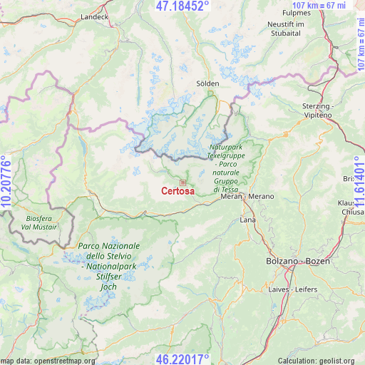
Certosa GPS coordinates[2]
46° 42' 16.2" North, 10° 54' 39.168" East
| Map corner | latitude | longitude |
|---|---|---|
| Upper-left | 47.18452°, | 10.20776° |
| Center: | 46.7045°, | 10.91088° |
| Lower-right: | 46.22017°, | 11.61401° |
| Map W x H: | 107.2×107.2 km | = 66.6×66.6mi |
| max Lat: | 47.04031° ⇑0.6% North |
| Certosa: | 46.7045° |
| min Lat: | ⇓99.4% South 35.50142° |
| min Long | Certosa | max Long |
| 6.69888° | 10.91088° | 18.48682° |
| W 41.6%⇐ | ⇒58.4% E |
Elevation
Elevation of Certosa is 1331 m = 4367 ft, and this is 1024.3 m = 3361 ft above average elevation for this country.
| Max E: |
2085 m = 6841 ft | 0.8% |
| Certosa | 1331 m 4367 ft | |
| Avg. | 306.7 m = 1006 ft | |
Min E: |
-4 m = -13 ft | 99.2% |
See also: Italy elevation on elevation.city.
Geographical zone
Certosa is located in North temperate zone (between Tropic of Cancer and the Arctic Circle). Distance of this North polar circle is 2208.1 km =1372 mi to North.| Distance of | km | miles | from Certosa |
|---|---|---|---|
| North Pole | 4814 | 2991.3 | to North |
| Arctic Circle | 2208.1 | 1372 | to North |
| Tropic Cancer | 2587.1 | 1607.5 | to South |
| Equator | 5193.1 | 3226.8 | to South |


Nearby cities:
15 places around Certosa: (largest is in red/bold)
• Castelbello
8.4 km =5.2 mi,  181°
181°
• Castelbello-Ciardes - Kastelbell-Tschars
8.5 km =5.3 mi, 182°
• Ciardes
7.7 km =4.8 mi,  162°
162°
• Coldrano
11.1 km =6.9 mi,  215°
215°
• Laces
10.6 km =6.6 mi,  202°
202°
• Lagundo
16.6 km =10.3 mi,  99°
99°
• Morter
12.8 km =8 mi,  211°
211°
• Naturno
9.3 km =5.8 mi,  132°
132°
• Parcines
12.6 km =7.8 mi, 100°
• Plaus
11.3 km =7 mi,  118°
118°
• Rablà
12.3 km =7.6 mi,  107°
107°
• Senales
0.3 km =0.2 mi,  312°
312°
• Silandro
13.8 km =8.6 mi,  232°
232°
• Tarres
11.2 km =7 mi,  193°
193°
• Zona Laurin
18.1 km =11.2 mi, 99°
Sources, notices
• [Note1] Compared only with cities in Italy existing in our database
• [Src1] Map data: © OpenStreetMap contributors (CC-BY-SA)
• [Src2] Other city data from geonames.org with taken over terms of usage.
• [Src3] Geographical zone / Annual Mean Temperature by Robert A. Rohde @ Wikipedia
