Courmayeur geodata
Courmayeur (Aosta Valley) is a seat of a third-order administrative division; located in Italy in Europe/Rome (GMT+2) time zone. With population of 2,794 people, there are 3223 cities with bigger population in this country. Compared to other cities in Italy, 85.6% of cities are located further ↓South; 99.9% of cities are located further →East and 98.8% of cities have lower elevation than Courmayeur. Note1


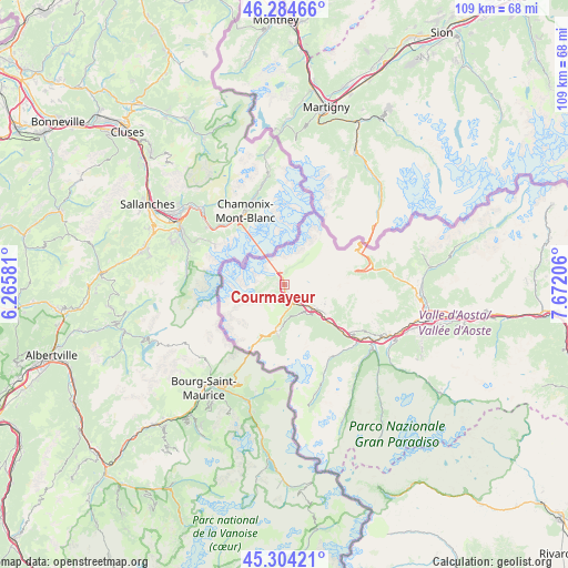
Courmayeur GPS coordinates[2]
45° 47' 47.724" North, 6° 58' 8.148" East
| Map corner | latitude | longitude |
|---|---|---|
| Upper-left | 46.28466°, | 6.26581° |
| Center: | 45.79659°, | 6.96893° |
| Lower-right: | 45.30421°, | 7.67206° |
| Map W x H: | 109×109 km | = 67.7×67.7mi |
| max Lat: | 47.04031° ⇑14.4% North |
| Courmayeur: | 45.79659° |
| min Lat: | ⇓85.6% South 35.50142° |
| min Long | Courmayeur | max Long |
| 6.69888° | 6.96893° | 18.48682° |
| W 0.1%⇐ | ⇒99.9% E |
Elevation
Elevation of Courmayeur is 1224 m = 4016 ft, and this is 917.3 m = 3010 ft above average elevation for this country.
| Max E: |
2085 m = 6841 ft | 1.2% |
| Courmayeur | 1224 m 4016 ft | |
| Avg. | 306.7 m = 1006 ft | |
Min E: |
-4 m = -13 ft | 98.8% |
See also: Italy elevation on elevation.city.
Geographical zone
Courmayeur is located in North temperate zone (between Tropic of Cancer and the Arctic Circle). Distance of this North polar circle is 2309.1 km =1434.8 mi to North.| Distance of | km | miles | from Courmayeur |
|---|---|---|---|
| North Pole | 4915 | 3054 | to North |
| Arctic Circle | 2309.1 | 1434.8 | to North |
| Tropic Cancer | 2486.2 | 1544.9 | to South |
| Equator | 5092.1 | 3164.1 | to South |


Nearby cities:
15 places around Courmayeur: (largest is in red/bold)
• Arvier
18.3 km =11.4 mi,  124°
124°
• Avise
16.5 km =10.3 mi,  126°
126°
• Etroubles
20.5 km =12.7 mi,  82°
82°
• Introd
20.2 km =12.6 mi, 124°
• La Salle
9.9 km =6.2 mi, 125°
• La Thuile
9.3 km =5.8 mi,  188°
188°
• Morgex
7.2 km =4.5 mi, 128°
• Plan d'Introd
20.3 km =12.6 mi, 124°
• Prè Saint Didier
3.8 km =2.4 mi,  160°
160°
• Saint-Nicolas
17.7 km =11 mi, 120°
• Saint-Oyen
19.2 km =11.9 mi, 80°
• Saint-Rhémy
17.2 km =10.7 mi, 75°
• San Leonardo
16.7 km =10.4 mi, 79°
• Valgrisenche
19.9 km =12.4 mi, 158°
• Villeneuve
21.2 km =13.2 mi, 119°
Sources, notices
• [Note1] Compared only with cities in Italy existing in our database
• [Src1] Map data: © OpenStreetMap contributors (CC-BY-SA)
• [Src2] Other city data from geonames.org with taken over terms of usage.
• [Src3] Geographical zone / Annual Mean Temperature by Robert A. Rohde @ Wikipedia
