San Leonardo geodata
San Leonardo (Aosta Valley) is a seat of a third-order administrative division; located in Italy in Europe/Rome (GMT+2) time zone. With population of 157 people, there are 11260 cities with bigger population in this country. Compared to other cities in Italy, 86.8% of cities are located further ↓South; 99.5% of cities are located further →East and 99.8% of cities have lower elevation than San Leonardo. Note1
Administrative division(s):
- Level 1: Aosta Valley
- Level 2: Valle d'Aosta
- Level 3: Saint-Rhémy-en-Bosses


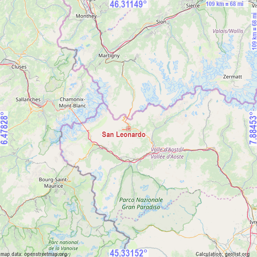
San Leonardo GPS coordinates[2]
45° 49' 25.176" North, 7° 10' 53.04" East
| Map corner | latitude | longitude |
|---|---|---|
| Upper-left | 46.31149°, | 6.47828° |
| Center: | 45.82366°, | 7.1814° |
| Lower-right: | 45.33152°, | 7.88453° |
| Map W x H: | 109×109 km | = 67.7×67.7mi |
| max Lat: | 47.04031° ⇑13.2% North |
| San Leonardo: | 45.82366° |
| min Lat: | ⇓86.8% South 35.50142° |
| min Long | San Leonardo | max Long |
| 6.69888° | 7.1814° | 18.48682° |
| W 0.5%⇐ | ⇒99.5% E |
Elevation
Elevation of San Leonardo is 1534 m = 5033 ft, and this is 1227.3 m = 4027 ft above average elevation for this country.
| Max E: |
2085 m = 6841 ft | 0.2% |
| San Leonardo | 1534 m 5033 ft | |
| Avg. | 306.7 m = 1006 ft | |
Min E: |
-4 m = -13 ft | 99.8% |
See also: Italy elevation on elevation.city.
Geographical zone
San Leonardo is located in North temperate zone (between Tropic of Cancer and the Arctic Circle). Distance of this North polar circle is 2306.1 km =1432.9 mi to North.| Distance of | km | miles | from San Leonardo |
|---|---|---|---|
| North Pole | 4911.9 | 3052.1 | to North |
| Arctic Circle | 2306.1 | 1432.9 | to North |
| Tropic Cancer | 2489.2 | 1546.7 | to South |
| Equator | 5095.1 | 3165.9 | to South |


Nearby cities:
15 places around San Leonardo: (largest is in red/bold)
• Allein
7.3 km =4.5 mi,  104°
104°
• Arpuilles
12.4 km =7.7 mi,  128°
128°
• Doues
9.7 km =6 mi,  92°
92°
• Etroubles
3.9 km =2.4 mi, 94°
• Gignod
10.2 km =6.3 mi,  118°
118°
• La Cretaz-Roisan
11.1 km =6.9 mi,  113°
113°
• La Salle
12.1 km =7.5 mi,  223°
223°
• Montan-Angelin-Arensod
12.9 km =8 mi,  145°
145°
• Ollomont
10.4 km =6.5 mi,  73°
73°
• Saint-Nicolas
12 km =7.5 mi,  185°
185°
• Saint-Oyen
2.5 km =1.6 mi, 88°
• Saint-Rhémy
1.3 km =0.8 mi,  8°
8°
• Valpelline
11.2 km =7 mi, 89°
• Variney Chez Roncoz
11.7 km =7.3 mi, 121°
• Ville Sur Sarre
11.7 km =7.3 mi, 149°
Sources, notices
• [Note1] Compared only with cities in Italy existing in our database
• [Src1] Map data: © OpenStreetMap contributors (CC-BY-SA)
• [Src2] Other city data from geonames.org with taken over terms of usage.
• [Src3] Geographical zone / Annual Mean Temperature by Robert A. Rohde @ Wikipedia
