Lama di Reno geodata
Lama di Reno (Emilia-Romagna) is a populated place; located in Italy in Europe/Rome (GMT+2) time zone. With population of 996 people, there are 6686 cities with bigger population in this country. Compared to other cities in Italy, 50.9% of cities are located further ↑North; 54.3% of cities are located further →East and 68.1% of cities have higher elevation than Lama di Reno. Note1


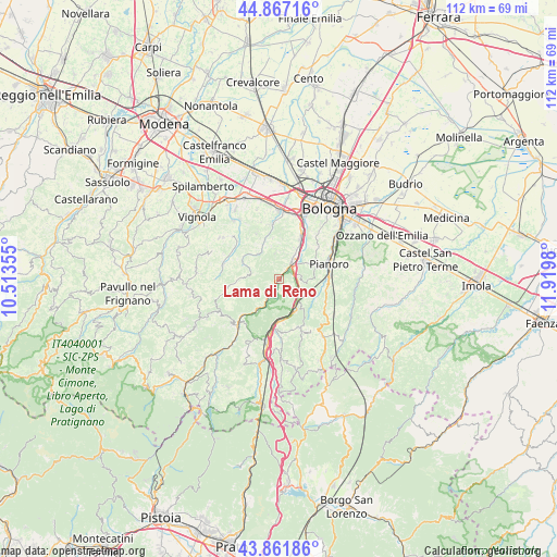
Lama di Reno GPS coordinates[2]
44° 22' 0.012" North, 11° 13' 0.012" East
| Map corner | latitude | longitude |
|---|---|---|
| Upper-left | 44.86716°, | 10.51355° |
| Center: | 44.36667°, | 11.21667° |
| Lower-right: | 43.86186°, | 11.9198° |
| Map W x H: | 111.8×111.8 km | = 69.5×69.5mi |
| max Lat: | 47.04031° ⇑50.9% North |
| Lama di Reno: | 44.36667° |
| min Lat: | ⇓49.1% South 35.50142° |
| min Long | Lama di Reno | max Long |
| 6.69888° | 11.21667° | 18.48682° |
| W 45.7%⇐ | ⇒54.3% E |
Elevation
Elevation of Lama di Reno is 108 m = 354 ft, and this is 198.7 m = 652 ft below average elevation for this country.
| Max E: |
2085 m = 6841 ft | 68.1% |
| Avg. | 306.7 m = 1006 ft | |
| Lama di Reno | 108 m = 354 ft | |
Min E: |
-4 m = -13 ft | 31.9% |
See also: Italy elevation on elevation.city.
Geographical zone
Lama di Reno is located in North temperate zone (between Tropic of Cancer and the Arctic Circle). Distance of this Northern Tropic circle is 2327.2 km =1446.1 mi to South.| Distance of | km | miles | from Lama di Reno |
|---|---|---|---|
| North Pole | 5074 | 3152.8 | to North |
| Arctic Circle | 2468.1 | 1533.6 | to North |
| Tropic Cancer | 2327.2 | 1446.1 | to South |
| Equator | 4933.1 | 3065.3 | to South |


Nearby cities:
15 places around Lama di Reno: (largest is in red/bold)
• Borgonuovo
8.8 km =5.5 mi,  29°
29°
• Calderino
10.2 km =6.3 mi,  352°
352°
• Fontana
2.6 km =1.6 mi,  40°
40°
• Marzabotto
2.8 km =1.7 mi,  197°
197°
• Monte San Giovanni
6.9 km =4.3 mi,  328°
328°
• Montepastore
7.4 km =4.6 mi,  271°
271°
• Monzuno
10.6 km =6.6 mi,  157°
157°
• Pian di Venola
4.4 km =2.7 mi,  211°
211°
• Pianoro
10.3 km =6.4 mi,  76°
76°
• Pioppe di Salvaro
7.7 km =4.8 mi, 214°
• Rioveggio
10.4 km =6.5 mi,  187°
187°
• Sasso Marconi
4.7 km =2.9 mi, 36°
• Savigno
11.6 km =7.2 mi,  283°
283°
• Vado
6.5 km =4 mi,  148°
148°
• Vergato
12.7 km =7.9 mi,  222°
222°
Sources, notices
• [Note1] Compared only with cities in Italy existing in our database
• [Src1] Map data: © OpenStreetMap contributors (CC-BY-SA)
• [Src2] Other city data from geonames.org with taken over terms of usage.
• [Src3] Geographical zone / Annual Mean Temperature by Robert A. Rohde @ Wikipedia
