Berchidda geodata
Berchidda (Sardinia) is a seat of a third-order administrative division; located in Italy in Europe/Rome (GMT+2) time zone. With population of 2,754 people, there are 3265 cities with bigger population in this country. Compared to other cities in Italy, 81.5% of cities are located further ↑North; 78.6% of cities are located further →East and 56.6% of cities have lower elevation than Berchidda. Note1


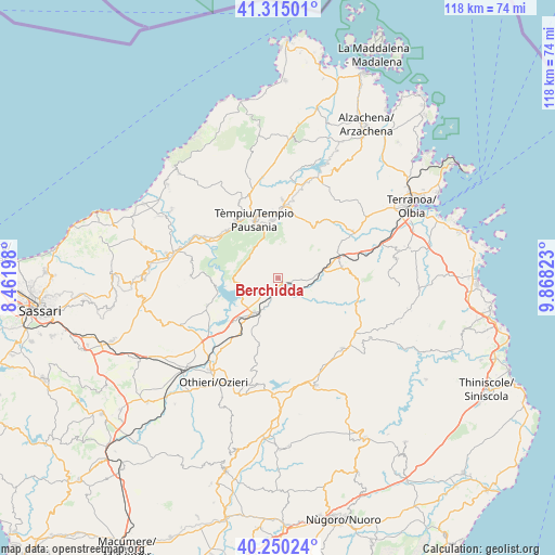
Berchidda GPS coordinates[2]
40° 47' 5.136" North, 9° 9' 54.36" East
| Map corner | latitude | longitude |
|---|---|---|
| Upper-left | 41.31501°, | 8.46198° |
| Center: | 40.78476°, | 9.1651° |
| Lower-right: | 40.25024°, | 9.86823° |
| Map W x H: | 118.4×118.4 km | = 73.6×73.6mi |
| max Lat: | 47.04031° ⇑81.5% North |
| Berchidda: | 40.78476° |
| min Lat: | ⇓18.5% South 35.50142° |
| min Long | Berchidda | max Long |
| 6.69888° | 9.1651° | 18.48682° |
| W 21.4%⇐ | ⇒78.6% E |
Elevation
Elevation of Berchidda is 276 m = 906 ft, and this is 30.7 m = 101 ft below average elevation for this country.
| Max E: |
2085 m = 6841 ft | 43.4% |
| Avg. | 306.7 m = 1006 ft | |
| Berchidda | 276 m = 906 ft | |
Min E: |
-4 m = -13 ft | 56.6% |
See also: Italy elevation on elevation.city.
Geographical zone
Berchidda is located in North temperate zone (between Tropic of Cancer and the Arctic Circle). Distance of this Northern Tropic circle is 1928.9 km =1198.6 mi to South.| Distance of | km | miles | from Berchidda |
|---|---|---|---|
| North Pole | 5472.2 | 3400.3 | to North |
| Arctic Circle | 2866.3 | 1781 | to North |
| Tropic Cancer | 1928.9 | 1198.6 | to South |
| Equator | 4534.8 | 2817.8 | to South |


Nearby cities:
15 places around Berchidda: (largest is in red/bold)
• Aggius
18.2 km =11.3 mi,  332°
332°
• Alà dei Sardi
20.3 km =12.6 mi,  137°
137°
• Bortigiadas
15.7 km =9.8 mi,  319°
319°
• Buddusò
24.4 km =15.2 mi,  161°
161°
• Calangianus
15.3 km =9.5 mi,  8°
8°
• Erula
18.6 km =11.6 mi,  272°
272°
• Luras
16.9 km =10.5 mi,  2°
2°
• Monti
13.7 km =8.5 mi,  79°
79°
• Oschiri
9 km =5.6 mi,  216°
216°
• Pattada
23.1 km =14.4 mi,  191°
191°
• Perfugas
24.3 km =15.1 mi,  282°
282°
• San Nicola
24.4 km =15.2 mi, 217°
• Telti
18.8 km =11.7 mi,  57°
57°
• Tempio Pausania
13.9 km =8.6 mi,  338°
338°
• Tula
16.3 km =10.1 mi,  249°
249°
Sources, notices
• [Note1] Compared only with cities in Italy existing in our database
• [Src1] Map data: © OpenStreetMap contributors (CC-BY-SA)
• [Src2] Other city data from geonames.org with taken over terms of usage.
• [Src3] Geographical zone / Annual Mean Temperature by Robert A. Rohde @ Wikipedia
