Guardiaregia geodata
Guardiaregia (Molise) is a seat of a third-order administrative division; located in Italy in Europe/Rome (GMT+2) time zone. With population of 453 people, there are 10081 cities with bigger population in this country. Compared to other cities in Italy, 75.3% of cities are located further ↑North; 83.1% of cities are located further ←West and 89.8% of cities have lower elevation than Guardiaregia. Note1


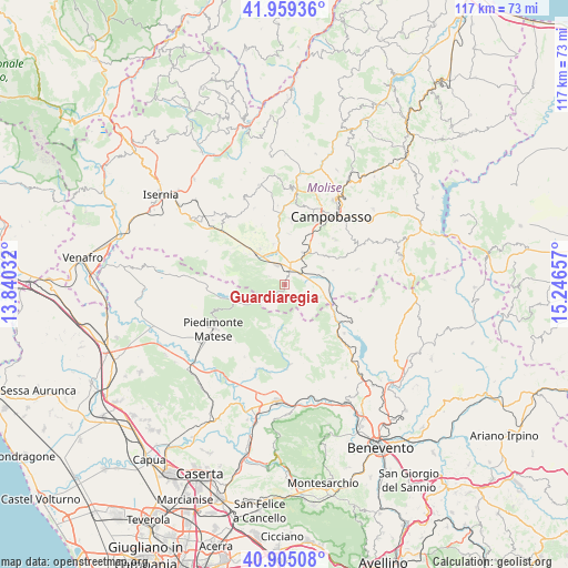
Guardiaregia GPS coordinates[2]
41° 26' 3.696" North, 14° 32' 36.384" East
| Map corner | latitude | longitude |
|---|---|---|
| Upper-left | 41.95936°, | 13.84032° |
| Center: | 41.43436°, | 14.54344° |
| Lower-right: | 40.90508°, | 15.24657° |
| Map W x H: | 117.2×117.2 km | = 72.8×72.8mi |
| max Lat: | 47.04031° ⇑75.3% North |
| Guardiaregia: | 41.43436° |
| min Lat: | ⇓24.7% South 35.50142° |
| min Long | Guardiaregia | max Long |
| 6.69888° | 14.54344° | 18.48682° |
| W 83.1%⇐ | ⇒16.9% E |
Elevation
Elevation of Guardiaregia is 715 m = 2346 ft, and this is 408.3 m = 1340 ft above average elevation for this country.
| Max E: |
2085 m = 6841 ft | 10.2% |
| Guardiaregia | 715 m 2346 ft | |
| Avg. | 306.7 m = 1006 ft | |
Min E: |
-4 m = -13 ft | 89.8% |
See also: Italy elevation on elevation.city.
Geographical zone
Guardiaregia is located in North temperate zone (between Tropic of Cancer and the Arctic Circle). Distance of this Northern Tropic circle is 2001.1 km =1243.4 mi to South.| Distance of | km | miles | from Guardiaregia |
|---|---|---|---|
| North Pole | 5400 | 3355.4 | to North |
| Arctic Circle | 2794.1 | 1736.2 | to North |
| Tropic Cancer | 2001.1 | 1243.4 | to South |
| Equator | 4607.1 | 2862.7 | to South |


Nearby cities:
15 places around Guardiaregia: (largest is in red/bold)
• Baranello
10.4 km =6.5 mi,  6°
6°
• Bojano
8.3 km =5.2 mi,  313°
313°
• Campochiaro
3.3 km =2.1 mi,  297°
297°
• Cercepiccola
10.5 km =6.5 mi,  74°
74°
• Colle d'Anchise
8.6 km =5.3 mi,  346°
346°
• Cusano Mutri
11.3 km =7 mi,  194°
194°
• Largo Zullo-Sterparo
10.3 km =6.4 mi,  22°
22°
• Monteverde
8.6 km =5.3 mi,  326°
326°
• Pietraroja
9.6 km =6 mi,  176°
176°
• San Giuliano del Sannio
8.6 km =5.3 mi, 72°
• San Massimo
12.9 km =8 mi, 300°
• San Polomatese
5 km =3.1 mi, 303°
• Sassinoro
12.1 km =7.5 mi,  123°
123°
• Sepino
7 km =4.3 mi,  114°
114°
• Vinchiaturo
7.7 km =4.8 mi,  31°
31°
Sources, notices
• [Note1] Compared only with cities in Italy existing in our database
• [Src1] Map data: © OpenStreetMap contributors (CC-BY-SA)
• [Src2] Other city data from geonames.org with taken over terms of usage.
• [Src3] Geographical zone / Annual Mean Temperature by Robert A. Rohde @ Wikipedia
