Montecchio geodata
Montecchio (Umbria) is a seat of a third-order administrative division; located in Italy in Europe/Rome (GMT+2) time zone. With population of 758 people, there are 7894 cities with bigger population in this country. Compared to other cities in Italy, 65.4% of cities are located further ↑North; 59.7% of cities are located further ←West and 68.2% of cities have lower elevation than Montecchio. Note1


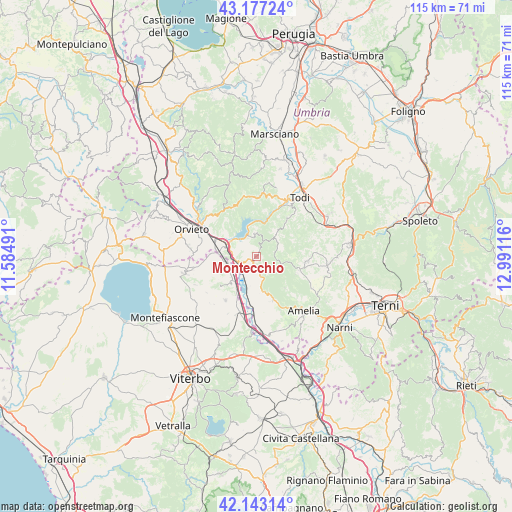
Montecchio GPS coordinates[2]
42° 39' 44.424" North, 12° 17' 16.908" East
| Map corner | latitude | longitude |
|---|---|---|
| Upper-left | 43.17724°, | 11.58491° |
| Center: | 42.66234°, | 12.28803° |
| Lower-right: | 42.14314°, | 12.99116° |
| Map W x H: | 115×115 km | = 71.5×71.5mi |
| max Lat: | 47.04031° ⇑65.4% North |
| Montecchio: | 42.66234° |
| min Lat: | ⇓34.6% South 35.50142° |
| min Long | Montecchio | max Long |
| 6.69888° | 12.28803° | 18.48682° |
| W 59.7%⇐ | ⇒40.3% E |
Elevation
Elevation of Montecchio is 375 m = 1230 ft, and this is 68.3 m = 224 ft above average elevation for this country.
| Max E: |
2085 m = 6841 ft | 31.8% |
| Montecchio | 375 m 1230 ft | |
| Avg. | 306.7 m = 1006 ft | |
Min E: |
-4 m = -13 ft | 68.2% |
See also: Italy elevation on elevation.city.
Geographical zone
Montecchio is located in North temperate zone (between Tropic of Cancer and the Arctic Circle). Distance of this Northern Tropic circle is 2137.7 km =1328.3 mi to South.| Distance of | km | miles | from Montecchio |
|---|---|---|---|
| North Pole | 5263.5 | 3270.6 | to North |
| Arctic Circle | 2657.6 | 1651.4 | to North |
| Tropic Cancer | 2137.7 | 1328.3 | to South |
| Equator | 4743.6 | 2947.5 | to South |


Nearby cities:
15 places around Montecchio: (largest is in red/bold)
• Alviano
8 km =5 mi,  174°
174°
• Avigliano Umbro
11.3 km =7 mi,  95°
95°
• Baschi
5.9 km =3.7 mi,  281°
281°
• Canale Nuovo
13 km =8.1 mi, 282°
• Castel dell'Aquila
10 km =6.2 mi,  107°
107°
• Castiglione in Teverina
7.1 km =4.4 mi,  259°
259°
• Ciconia
14.9 km =9.3 mi,  302°
302°
• Civitella d'Agliano
10.6 km =6.6 mi,  231°
231°
• Graffignano
12 km =7.5 mi,  216°
216°
• Guardea
4.4 km =2.7 mi, 167°
• Lubriano
14.9 km =9.3 mi, 258°
• Lugnano in Teverina
10.3 km =6.4 mi,  158°
158°
• Orvieto Scalo
14.2 km =8.8 mi, 297°
• Porano
15.2 km =9.4 mi, 277°
• Sipicciano
14 km =8.7 mi,  200°
200°
Sources, notices
• [Note1] Compared only with cities in Italy existing in our database
• [Src1] Map data: © OpenStreetMap contributors (CC-BY-SA)
• [Src2] Other city data from geonames.org with taken over terms of usage.
• [Src3] Geographical zone / Annual Mean Temperature by Robert A. Rohde @ Wikipedia
