Orvieto Scalo geodata
Orvieto Scalo (Umbria) is a populated place; located in Italy in Europe/Rome (GMT+2) time zone. With population of 2,285 people, there are 3777 cities with bigger population in this country. Compared to other cities in Italy, 65.1% of cities are located further ↑North; 57.8% of cities are located further ←West and 66.5% of cities have higher elevation than Orvieto Scalo. Note1


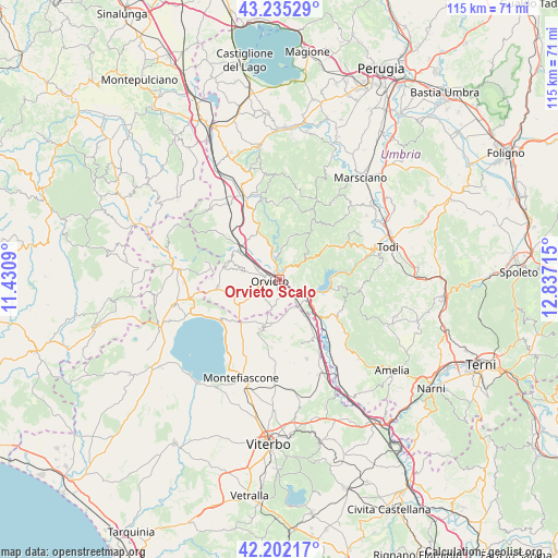
Orvieto Scalo GPS coordinates[2]
42° 43' 15.168" North, 12° 8' 2.472" East
| Map corner | latitude | longitude |
|---|---|---|
| Upper-left | 43.23529°, | 11.4309° |
| Center: | 42.72088°, | 12.13402° |
| Lower-right: | 42.20217°, | 12.83715° |
| Map W x H: | 114.9×114.9 km | = 71.4×71.4mi |
| max Lat: | 47.04031° ⇑65.1% North |
| Orvieto Scalo: | 42.72088° |
| min Lat: | ⇓34.9% South 35.50142° |
| min Long | Orvieto Scalo | max Long |
| 6.69888° | 12.13402° | 18.48682° |
| W 57.8%⇐ | ⇒42.2% E |
Elevation
Elevation of Orvieto Scalo is 118 m = 387 ft, and this is 188.7 m = 619 ft below average elevation for this country.
| Max E: |
2085 m = 6841 ft | 66.5% |
| Avg. | 306.7 m = 1006 ft | |
| Orvieto Scalo | 118 m = 387 ft | |
Min E: |
-4 m = -13 ft | 33.5% |
See also: Italy elevation on elevation.city.
Geographical zone
Orvieto Scalo is located in North temperate zone (between Tropic of Cancer and the Arctic Circle). Distance of this Northern Tropic circle is 2144.2 km =1332.3 mi to South.| Distance of | km | miles | from Orvieto Scalo |
|---|---|---|---|
| North Pole | 5256.9 | 3266.5 | to North |
| Arctic Circle | 2651.1 | 1647.3 | to North |
| Tropic Cancer | 2144.2 | 1332.3 | to South |
| Equator | 4750.1 | 2951.6 | to South |


Nearby cities:
15 places around Orvieto Scalo: (largest is in red/bold)
• Bagnoregio
10.9 km =6.8 mi,  199°
199°
• Baschi
8.6 km =5.3 mi,  127°
127°
• Canale Nuovo
3.7 km =2.3 mi,  182°
182°
• Castel Giorgio
12.9 km =8 mi,  263°
263°
• Castel Viscardo
11.5 km =7.1 mi,  288°
288°
• Castiglione in Teverina
9.6 km =6 mi,  144°
144°
• Ciconia
1.4 km =0.9 mi,  359°
359°
• Ficulle
13.5 km =8.4 mi,  336°
336°
• Lubriano
9.6 km =6 mi,  192°
192°
• Monterubiaglio
10.9 km =6.8 mi,  297°
297°
• Orvieto
1.8 km =1.1 mi, 264°
• Pianlungo
10.5 km =6.5 mi,  310°
310°
• Porano
5.1 km =3.2 mi,  209°
209°
• Sferracavallo
3.2 km =2 mi,  280°
280°
• Stazione di Allerona
10.7 km =6.6 mi, 312°
Sources, notices
• [Note1] Compared only with cities in Italy existing in our database
• [Src1] Map data: © OpenStreetMap contributors (CC-BY-SA)
• [Src2] Other city data from geonames.org with taken over terms of usage.
• [Src3] Geographical zone / Annual Mean Temperature by Robert A. Rohde @ Wikipedia
