Guardea geodata
Guardea (Umbria) is a seat of a third-order administrative division; located in Italy in Europe/Rome (GMT+2) time zone. With population of 1,203 people, there are 5950 cities with bigger population in this country. Compared to other cities in Italy, 65.6% of cities are located further ↑North; 59.9% of cities are located further ←West and 69.6% of cities have lower elevation than Guardea. Note1


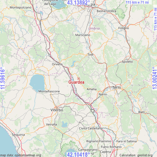
Guardea GPS coordinates[2]
42° 37' 25.32" North, 12° 17' 57.408" East
| Map corner | latitude | longitude |
|---|---|---|
| Upper-left | 43.13892°, | 11.59616° |
| Center: | 42.6237°, | 12.29928° |
| Lower-right: | 42.10418°, | 13.00241° |
| Map W x H: | 115.1×115.1 km | = 71.5×71.5mi |
| max Lat: | 47.04031° ⇑65.6% North |
| Guardea: | 42.6237° |
| min Lat: | ⇓34.4% South 35.50142° |
| min Long | Guardea | max Long |
| 6.69888° | 12.29928° | 18.48682° |
| W 59.9%⇐ | ⇒40.1% E |
Elevation
Elevation of Guardea is 390 m = 1280 ft, and this is 83.3 m = 273 ft above average elevation for this country.
| Max E: |
2085 m = 6841 ft | 30.4% |
| Guardea | 390 m 1280 ft | |
| Avg. | 306.7 m = 1006 ft | |
Min E: |
-4 m = -13 ft | 69.6% |
See also: Italy elevation on elevation.city.
Geographical zone
Guardea is located in North temperate zone (between Tropic of Cancer and the Arctic Circle). Distance of this Northern Tropic circle is 2133.4 km =1325.6 mi to South.| Distance of | km | miles | from Guardea |
|---|---|---|---|
| North Pole | 5267.8 | 3273.3 | to North |
| Arctic Circle | 2661.9 | 1654 | to North |
| Tropic Cancer | 2133.4 | 1325.6 | to South |
| Equator | 4739.3 | 2944.9 | to South |


Nearby cities:
15 places around Guardea: (largest is in red/bold)
• Alviano
3.7 km =2.3 mi,  181°
181°
• Amelia
12.8 km =8 mi,  128°
128°
• Attigliano
12.1 km =7.5 mi, 181°
• Avigliano Umbro
10.8 km =6.7 mi,  72°
72°
• Baschi
8.7 km =5.4 mi,  309°
309°
• Canale Nuovo
15.4 km =9.6 mi,  297°
297°
• Castel dell'Aquila
8.8 km =5.5 mi,  81°
81°
• Castiglione in Teverina
8.4 km =5.2 mi,  290°
290°
• Civitella d'Agliano
9.5 km =5.9 mi,  256°
256°
• Giove
12.9 km =8 mi,  168°
168°
• Graffignano
9.7 km =6 mi,  236°
236°
• Lugnano in Teverina
6 km =3.7 mi,  152°
152°
• Montecchio
4.4 km =2.7 mi,  347°
347°
• Penna in Teverina
15.3 km =9.5 mi,  161°
161°
• Sipicciano
10.6 km =6.6 mi,  213°
213°
Sources, notices
• [Note1] Compared only with cities in Italy existing in our database
• [Src1] Map data: © OpenStreetMap contributors (CC-BY-SA)
• [Src2] Other city data from geonames.org with taken over terms of usage.
• [Src3] Geographical zone / Annual Mean Temperature by Robert A. Rohde @ Wikipedia
