Montebelluna geodata
Montebelluna (Veneto) is a seat of a third-order administrative division; located in Italy in Europe/Rome (GMT+2) time zone. With population of 26,670 people, there are 302 cities with bigger population in this country. Compared to other cities in Italy, 84.7% of cities are located further ↓South; 56.5% of cities are located further ←West and 67.5% of cities have higher elevation than Montebelluna. Note1


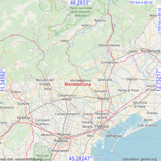
Montebelluna GPS coordinates[2]
45° 46' 30.144" North, 12° 2' 56.544" East
| Map corner | latitude | longitude |
|---|---|---|
| Upper-left | 46.2633°, | 11.34592° |
| Center: | 45.77504°, | 12.04904° |
| Lower-right: | 45.28247°, | 12.75217° |
| Map W x H: | 109.1×109.1 km | = 67.8×67.8mi |
| max Lat: | 47.04031° ⇑15.3% North |
| Montebelluna: | 45.77504° |
| min Lat: | ⇓84.7% South 35.50142° |
| min Long | Montebelluna | max Long |
| 6.69888° | 12.04904° | 18.48682° |
| W 56.5%⇐ | ⇒43.5% E |
Elevation
Elevation of Montebelluna is 112 m = 367 ft, and this is 194.7 m = 639 ft below average elevation for this country.
| Max E: |
2085 m = 6841 ft | 67.5% |
| Avg. | 306.7 m = 1006 ft | |
| Montebelluna | 112 m = 367 ft | |
Min E: |
-4 m = -13 ft | 32.5% |
See also: Italy elevation on elevation.city.
Geographical zone
Montebelluna is located in North temperate zone (between Tropic of Cancer and the Arctic Circle). Distance of this North polar circle is 2311.5 km =1436.3 mi to North.| Distance of | km | miles | from Montebelluna |
|---|---|---|---|
| North Pole | 4917.4 | 3055.5 | to North |
| Arctic Circle | 2311.5 | 1436.3 | to North |
| Tropic Cancer | 2483.8 | 1543.4 | to South |
| Equator | 5089.7 | 3162.6 | to South |


Nearby cities:
15 places around Montebelluna: (largest is in red/bold)
• Barcon
6.6 km =4.1 mi,  205°
205°
• Busta
4.9 km =3 mi,  229°
229°
• Caerano di San Marco
4 km =2.5 mi,  280°
280°
• Caselle
6.1 km =3.8 mi,  242°
242°
• Ciano
5.4 km =3.4 mi,  4°
4°
• Cornuda
7.1 km =4.4 mi,  332°
332°
• Crocetta del Montello
7 km =4.3 mi,  350°
350°
• Crocetta-Nogarè
6 km =3.7 mi, 345°
• Falze
4.8 km =3 mi,  135°
135°
• Falzè-Signoressa
5.3 km =3.3 mi,  121°
121°
• Maser
6.8 km =4.2 mi,  302°
302°
• Muliparte
6.8 km =4.2 mi,  312°
312°
• Trevignano
4.5 km =2.8 mi,  161°
161°
• Venegazzù
3.3 km =2.1 mi,  81°
81°
• Volpago del Montello
5.4 km =3.4 mi,  86°
86°
Sources, notices
• [Note1] Compared only with cities in Italy existing in our database
• [Src1] Map data: © OpenStreetMap contributors (CC-BY-SA)
• [Src2] Other city data from geonames.org with taken over terms of usage.
• [Src3] Geographical zone / Annual Mean Temperature by Robert A. Rohde @ Wikipedia
