Maser geodata
Maser (Veneto) is a seat of a third-order administrative division; located in Italy in Europe/Rome (GMT+2) time zone. With population of 1,498 people, there are 5121 cities with bigger population in this country. Compared to other cities in Italy, 86% of cities are located further ↓South; 55.5% of cities are located further ←West and 63% of cities have higher elevation than Maser. Note1


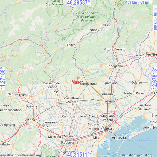
Maser GPS coordinates[2]
45° 48' 26.64" North, 11° 58' 30" East
| Map corner | latitude | longitude |
|---|---|---|
| Upper-left | 46.29537°, | 11.27188° |
| Center: | 45.8074°, | 11.975° |
| Lower-right: | 45.31511°, | 12.67813° |
| Map W x H: | 109×109 km | = 67.7×67.7mi |
| max Lat: | 47.04031° ⇑14% North |
| Maser: | 45.8074° |
| min Lat: | ⇓86% South 35.50142° |
| min Long | Maser | max Long |
| 6.69888° | 11.975° | 18.48682° |
| W 55.5%⇐ | ⇒44.5% E |
Elevation
Elevation of Maser is 141 m = 463 ft, and this is 165.7 m = 544 ft below average elevation for this country.
| Max E: |
2085 m = 6841 ft | 63% |
| Avg. | 306.7 m = 1006 ft | |
| Maser | 141 m = 463 ft | |
Min E: |
-4 m = -13 ft | 37% |
See also: Italy elevation on elevation.city.
Geographical zone
Maser is located in North temperate zone (between Tropic of Cancer and the Arctic Circle). Distance of this North polar circle is 2307.9 km =1434.1 mi to North.| Distance of | km | miles | from Maser |
|---|---|---|---|
| North Pole | 4913.8 | 3053.3 | to North |
| Arctic Circle | 2307.9 | 1434.1 | to North |
| Tropic Cancer | 2487.4 | 1545.6 | to South |
| Equator | 5093.3 | 3164.8 | to South |


Nearby cities:
15 places around Maser: (largest is in red/bold)
• Altivole
6.1 km =3.8 mi,  193°
193°
• Asolo
5 km =3.1 mi,  244°
244°
• Caerano di San Marco
3.4 km =2.1 mi,  147°
147°
• Caselle
6.4 km =4 mi,  176°
176°
• Ciano
6.4 km =4 mi,  73°
73°
• Cornuda
3.6 km =2.2 mi,  41°
41°
• Covolo-Levada
5.1 km =3.2 mi,  27°
27°
• Crespignaga
2.9 km =1.8 mi, 238°
• Crocetta del Montello
5.6 km =3.5 mi,  54°
54°
• Crocetta-Nogarè
4.8 km =3 mi,  62°
62°
• Monfumo
5 km =3.1 mi,  301°
301°
• Montebelluna
6.8 km =4.2 mi,  122°
122°
• Muliparte
1.2 km =0.7 mi, 38°
• Onigo
5.6 km =3.5 mi,  12°
12°
• Pagnano
6.7 km =4.2 mi,  271°
271°
Sources, notices
• [Note1] Compared only with cities in Italy existing in our database
• [Src1] Map data: © OpenStreetMap contributors (CC-BY-SA)
• [Src2] Other city data from geonames.org with taken over terms of usage.
• [Src3] Geographical zone / Annual Mean Temperature by Robert A. Rohde @ Wikipedia
