Trevignano geodata
Trevignano (Veneto) is a populated place; located in Italy in Europe/Rome (GMT+2) time zone. With population of 2,179 people, there are 3901 cities with bigger population in this country. Compared to other cities in Italy, 82.9% of cities are located further ↓South; 56.8% of cities are located further ←West and 74.7% of cities have higher elevation than Trevignano. Note1


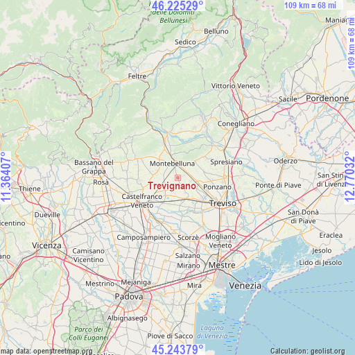
Trevignano GPS coordinates[2]
45° 44' 12.12" North, 12° 4' 1.884" East
| Map corner | latitude | longitude |
|---|---|---|
| Upper-left | 46.22529°, | 11.36407° |
| Center: | 45.7367°, | 12.06719° |
| Lower-right: | 45.24379°, | 12.77032° |
| Map W x H: | 109.1×109.1 km | = 67.8×67.8mi |
| max Lat: | 47.04031° ⇑17.1% North |
| Trevignano: | 45.7367° |
| min Lat: | ⇓82.9% South 35.50142° |
| min Long | Trevignano | max Long |
| 6.69888° | 12.06719° | 18.48682° |
| W 56.8%⇐ | ⇒43.2% E |
Elevation
Elevation of Trevignano is 75 m = 246 ft, and this is 231.7 m = 760 ft below average elevation for this country.
| Max E: |
2085 m = 6841 ft | 74.7% |
| Avg. | 306.7 m = 1006 ft | |
| Trevignano | 75 m = 246 ft | |
Min E: |
-4 m = -13 ft | 25.3% |
See also: Italy elevation on elevation.city.
Geographical zone
Trevignano is located in North temperate zone (between Tropic of Cancer and the Arctic Circle). Distance of this North polar circle is 2315.7 km =1438.9 mi to North.| Distance of | km | miles | from Trevignano |
|---|---|---|---|
| North Pole | 4921.6 | 3058.1 | to North |
| Arctic Circle | 2315.7 | 1438.9 | to North |
| Tropic Cancer | 2479.5 | 1540.7 | to South |
| Equator | 5085.4 | 3159.9 | to South |


Nearby cities:
15 places around Trevignano: (largest is in red/bold)
• Barcon
4.5 km =2.8 mi,  248°
248°
• Busta
5.2 km =3.2 mi,  281°
281°
• Falze
2.1 km =1.3 mi,  68°
68°
• Falzè-Signoressa
3.5 km =2.2 mi,  64°
64°
• Fanzolo
6.6 km =4.1 mi, 245°
• Fossalunga
5.1 km =3.2 mi,  192°
192°
• Montebelluna
4.5 km =2.8 mi,  341°
341°
• Musano
4.1 km =2.5 mi,  106°
106°
• Pezzan
5.3 km =3.3 mi,  154°
154°
• Porcellengo
6.7 km =4.2 mi,  120°
120°
• Postioma
6.9 km =4.3 mi, 107°
• Sala
4.3 km =2.7 mi, 149°
• Vedelago
6.7 km =4.2 mi,  214°
214°
• Venegazzù
5.1 km =3.2 mi,  21°
21°
• Volpago del Montello
6.1 km =3.8 mi,  41°
41°
Sources, notices
• [Note1] Compared only with cities in Italy existing in our database
• [Src1] Map data: © OpenStreetMap contributors (CC-BY-SA)
• [Src2] Other city data from geonames.org with taken over terms of usage.
• [Src3] Geographical zone / Annual Mean Temperature by Robert A. Rohde @ Wikipedia
