Aguscello geodata
Aguscello (Emilia-Romagna) is a populated place; located in Italy in Europe/Rome (GMT+2) time zone. With population of 524 people, there are 9692 cities with bigger population in this country. Compared to other cities in Italy, 56.3% of cities are located further ↓South; 51.3% of cities are located further ←West and 97.2% of cities have higher elevation than Aguscello. Note1


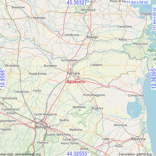
Aguscello GPS coordinates[2]
44° 48' 23.652" North, 11° 39' 35.712" East
| Map corner | latitude | longitude |
|---|---|---|
| Upper-left | 45.30327°, | 10.9568° |
| Center: | 44.80657°, | 11.65992° |
| Lower-right: | 44.30555°, | 12.36305° |
| Map W x H: | 110.9×110.9 km | = 68.9×68.9mi |
| max Lat: | 47.04031° ⇑43.7% North |
| Aguscello: | 44.80657° |
| min Lat: | ⇓56.3% South 35.50142° |
| min Long | Aguscello | max Long |
| 6.69888° | 11.65992° | 18.48682° |
| W 51.3%⇐ | ⇒48.7% E |
Elevation
Elevation of Aguscello is 5 m = 16 ft, and this is 301.7 m = 990 ft below average elevation for this country.
| Max E: |
2085 m = 6841 ft | 97.2% |
| Avg. | 306.7 m = 1006 ft | |
| Aguscello | 5 m = 16 ft | |
Min E: |
-4 m = -13 ft | 2.8% |
See also: Italy elevation on elevation.city.
Geographical zone
Aguscello is located in North temperate zone (between Tropic of Cancer and the Arctic Circle). Distance of this Northern Tropic circle is 2376.1 km =1476.4 mi to South.| Distance of | km | miles | from Aguscello |
|---|---|---|---|
| North Pole | 5025 | 3122.4 | to North |
| Arctic Circle | 2419.2 | 1503.2 | to North |
| Tropic Cancer | 2376.1 | 1476.4 | to South |
| Equator | 4982 | 3095.7 | to South |


Nearby cities:
15 places around Aguscello: (largest is in red/bold)
• Baura
6.9 km =4.3 mi,  42°
42°
• Boara
6.6 km =4.1 mi,  17°
17°
• Cona
3.7 km =2.3 mi,  91°
91°
• Ferrara
4.7 km =2.9 mi,  318°
318°
• Fossanova San Marco
3 km =1.9 mi,  232°
232°
• Gaibanella-Sant'Edigio
4.5 km =2.8 mi,  190°
190°
• Marrara
9.5 km =5.9 mi,  167°
167°
• Monestirolo
8.3 km =5.2 mi,  164°
164°
• Montalbano
8.9 km =5.5 mi, 228°
• Pontegradella
3.5 km =2.2 mi,  3°
3°
• Porotto-Cassama
9.9 km =6.2 mi,  299°
299°
• Quartesana
6.2 km =3.9 mi, 91°
• San Bartolomeo In Bosco
8.6 km =5.3 mi, 192°
• San Martino
6.5 km =4 mi,  240°
240°
• Voghiera
9.2 km =5.7 mi,  128°
128°
Sources, notices
• [Note1] Compared only with cities in Italy existing in our database
• [Src1] Map data: © OpenStreetMap contributors (CC-BY-SA)
• [Src2] Other city data from geonames.org with taken over terms of usage.
• [Src3] Geographical zone / Annual Mean Temperature by Robert A. Rohde @ Wikipedia
