Minerbio geodata
Minerbio (Emilia-Romagna) is a seat of a third-order administrative division; located in Italy in Europe/Rome (GMT+2) time zone. With population of 4,903 people, there are 1990 cities with bigger population in this country. Compared to other cities in Italy, 52.8% of cities are located further ↓South; 50.9% of cities are located further →East and 93% of cities have higher elevation than Minerbio. Note1


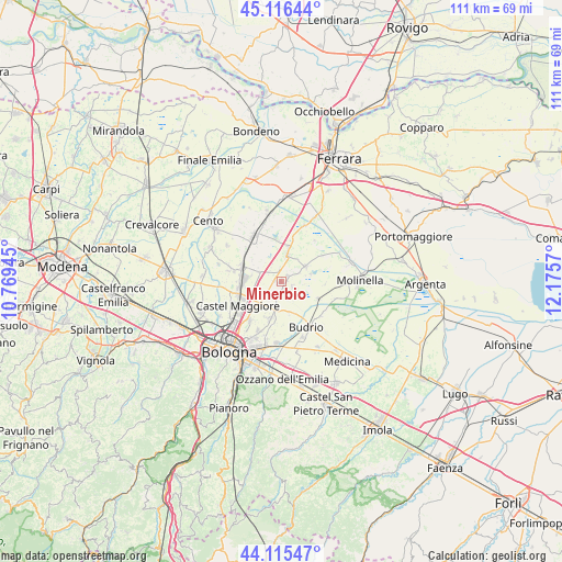
Minerbio GPS coordinates[2]
44° 37' 5.196" North, 11° 28' 21.252" East
| Map corner | latitude | longitude |
|---|---|---|
| Upper-left | 45.11644°, | 10.76945° |
| Center: | 44.61811°, | 11.47257° |
| Lower-right: | 44.11547°, | 12.1757° |
| Map W x H: | 111.3×111.3 km | = 69.2×69.2mi |
| max Lat: | 47.04031° ⇑47.2% North |
| Minerbio: | 44.61811° |
| min Lat: | ⇓52.8% South 35.50142° |
| min Long | Minerbio | max Long |
| 6.69888° | 11.47257° | 18.48682° |
| W 49.1%⇐ | ⇒50.9% E |
Elevation
Elevation of Minerbio is 12 m = 39 ft, and this is 294.7 m = 967 ft below average elevation for this country.
| Max E: |
2085 m = 6841 ft | 93% |
| Avg. | 306.7 m = 1006 ft | |
| Minerbio | 12 m = 39 ft | |
Min E: |
-4 m = -13 ft | 7% |
See also: Italy elevation on elevation.city.
Geographical zone
Minerbio is located in North temperate zone (between Tropic of Cancer and the Arctic Circle). Distance of this Northern Tropic circle is 2355.1 km =1463.4 mi to South.| Distance of | km | miles | from Minerbio |
|---|---|---|---|
| North Pole | 5046 | 3135.4 | to North |
| Arctic Circle | 2440.1 | 1516.2 | to North |
| Tropic Cancer | 2355.1 | 1463.4 | to South |
| Equator | 4961.1 | 3082.7 | to South |


Nearby cities:
15 places around Minerbio: (largest is in red/bold)
• Altedo
6 km =3.7 mi,  13°
13°
• Baricella
6.2 km =3.9 mi,  57°
57°
• Bentivoglio
4.8 km =3 mi,  295°
295°
• Cadriano
9.8 km =6.1 mi,  219°
219°
• Castagnolo Minore
7.3 km =4.5 mi,  261°
261°
• Castel Maggiore
10 km =6.2 mi,  242°
242°
• Cà Dè Fabbri
1.4 km =0.9 mi,  276°
276°
• Granarolo dell'Emilia e Viadagola
7.6 km =4.7 mi,  198°
198°
• Lovoleto
5 km =3.1 mi,  226°
226°
• Mezzolara
8 km =5 mi,  113°
113°
• Pegola
8.4 km =5.2 mi,  15°
15°
• San Giorgio di Piano
8.4 km =5.2 mi,  292°
292°
• San Marino
4.3 km =2.7 mi,  249°
249°
• Santa Maria in Duno
6 km =3.7 mi, 281°
• Stiatico
8.8 km =5.5 mi,  270°
270°
Sources, notices
• [Note1] Compared only with cities in Italy existing in our database
• [Src1] Map data: © OpenStreetMap contributors (CC-BY-SA)
• [Src2] Other city data from geonames.org with taken over terms of usage.
• [Src3] Geographical zone / Annual Mean Temperature by Robert A. Rohde @ Wikipedia
