Ambrogio geodata
Ambrogio (Emilia-Romagna) is a populated place; located in Italy in Europe/Rome (GMT+2) time zone. With population of 959 people, there are 6828 cities with bigger population in this country. Compared to other cities in Italy, 58.1% of cities are located further ↓South; 54.7% of cities are located further ←West and 99.7% of cities have higher elevation than Ambrogio. Note1


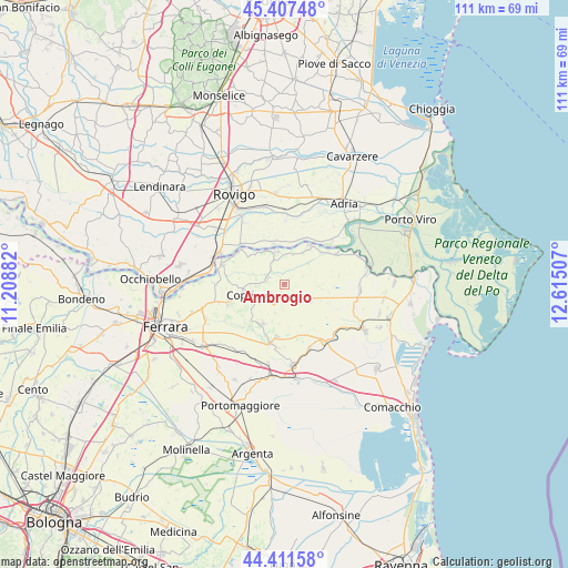
Ambrogio GPS coordinates[2]
44° 54' 42.084" North, 11° 54' 42.984" East
| Map corner | latitude | longitude |
|---|---|---|
| Upper-left | 45.40748°, | 11.20882° |
| Center: | 44.91169°, | 11.91194° |
| Lower-right: | 44.41158°, | 12.61507° |
| Map W x H: | 110.7×110.7 km | = 68.8×68.8mi |
| max Lat: | 47.04031° ⇑41.9% North |
| Ambrogio: | 44.91169° |
| min Lat: | ⇓58.1% South 35.50142° |
| min Long | Ambrogio | max Long |
| 6.69888° | 11.91194° | 18.48682° |
| W 54.7%⇐ | ⇒45.3% E |
Elevation
Elevation of Ambrogio is 0 m = 0 ft, and this is 306.7 m = 1006 ft below average elevation for this country.
| Max E: |
2085 m = 6841 ft | 99.7% |
| Avg. | 306.7 m = 1006 ft | |
| Ambrogio | 0 m = 0 ft | |
Min E: |
-4 m = -13 ft | 0.3% |
See also: Italy elevation on elevation.city.
Geographical zone
Ambrogio is located in North temperate zone (between Tropic of Cancer and the Arctic Circle). Distance of this Northern Tropic circle is 2387.8 km =1483.7 mi to South.| Distance of | km | miles | from Ambrogio |
|---|---|---|---|
| North Pole | 5013.4 | 3115.2 | to North |
| Arctic Circle | 2407.5 | 1496 | to North |
| Tropic Cancer | 2387.8 | 1483.7 | to South |
| Equator | 4993.7 | 3102.9 | to South |


Nearby cities:
15 places around Ambrogio: (largest is in red/bold)
• Alberone
8.9 km =5.5 mi,  311°
311°
• Berra
8.9 km =5.5 mi,  35°
35°
• Braglia
12.5 km =7.8 mi,  49°
49°
• Coccanile-Cesta
3.6 km =2.2 mi,  278°
278°
• Cologna
6.5 km =4 mi,  348°
348°
• Copparo
7.3 km =4.5 mi,  253°
253°
• Crespino
8.4 km =5.2 mi, 347°
• Formignana
8.8 km =5.5 mi,  208°
208°
• Guarda Veneta
11.7 km =7.3 mi, 311°
• Jolanda di Savoia
6.2 km =3.9 mi,  120°
120°
• La Saletta-Tamara
11.5 km =7.1 mi, 253°
• Papozze
12.5 km =7.8 mi, 48°
• Serravalle
12.2 km =7.6 mi,  60°
60°
• Tresigallo-Final di Rero
10.7 km =6.6 mi,  187°
187°
• Villanova Marchesana
9.9 km =6.2 mi,  25°
25°
Sources, notices
• [Note1] Compared only with cities in Italy existing in our database
• [Src1] Map data: © OpenStreetMap contributors (CC-BY-SA)
• [Src2] Other city data from geonames.org with taken over terms of usage.
• [Src3] Geographical zone / Annual Mean Temperature by Robert A. Rohde @ Wikipedia
