Formignana geodata
Formignana (Emilia-Romagna) is a seat of a third-order administrative division; located in Italy in Europe/Rome (GMT+2) time zone. With population of 1,974 people, there are 4202 cities with bigger population in this country. Compared to other cities in Italy, 57% of cities are located further ↓South; 53.9% of cities are located further ←West and 97.8% of cities have higher elevation than Formignana. Note1
Administrative division(s):
- Level 1: Emilia-Romagna
- Level 2: Provincia di Ferrara
- Level 3: Tresignana


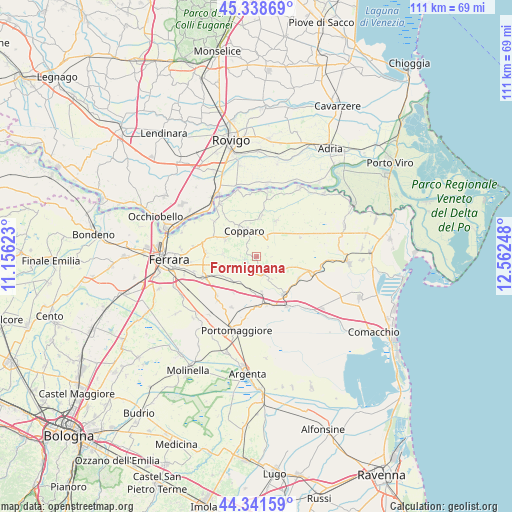
Formignana GPS coordinates[2]
44° 50' 32.28" North, 11° 51' 33.66" East
| Map corner | latitude | longitude |
|---|---|---|
| Upper-left | 45.33869°, | 11.15623° |
| Center: | 44.8423°, | 11.85935° |
| Lower-right: | 44.34159°, | 12.56248° |
| Map W x H: | 110.9×110.9 km | = 68.9×68.9mi |
| max Lat: | 47.04031° ⇑43% North |
| Formignana: | 44.8423° |
| min Lat: | ⇓57% South 35.50142° |
| min Long | Formignana | max Long |
| 6.69888° | 11.85935° | 18.48682° |
| W 53.9%⇐ | ⇒46.1% E |
Elevation
Elevation of Formignana is 4 m = 13 ft, and this is 302.7 m = 993 ft below average elevation for this country.
| Max E: |
2085 m = 6841 ft | 97.8% |
| Avg. | 306.7 m = 1006 ft | |
| Formignana | 4 m = 13 ft | |
Min E: |
-4 m = -13 ft | 2.2% |
See also: Italy elevation on elevation.city.
Geographical zone
Formignana is located in North temperate zone (between Tropic of Cancer and the Arctic Circle). Distance of this Northern Tropic circle is 2380.1 km =1478.9 mi to South.| Distance of | km | miles | from Formignana |
|---|---|---|---|
| North Pole | 5021.1 | 3120 | to North |
| Arctic Circle | 2415.2 | 1500.7 | to North |
| Tropic Cancer | 2380.1 | 1478.9 | to South |
| Equator | 4986 | 3098.2 | to South |


Nearby cities:
15 places around Formignana: (largest is in red/bold)
• Ambrogio
8.8 km =5.5 mi,  28°
28°
• Baura
11.2 km =7 mi,  275°
275°
• Coccanile-Cesta
8.3 km =5.2 mi,  3°
3°
• Copparo
6.3 km =3.9 mi,  332°
332°
• Dogato
10.6 km =6.6 mi,  167°
167°
• Gambulaga
12.2 km =7.6 mi,  206°
206°
• Jolanda di Savoia
10.5 km =6.5 mi,  64°
64°
• La Saletta-Tamara
8.1 km =5 mi,  302°
302°
• Masi-Torello
7 km =4.3 mi,  220°
220°
• Massa Fiscaglia
12.2 km =7.6 mi,  107°
107°
• Migliarino
9.9 km =6.2 mi,  144°
144°
• Migliaro
10.3 km =6.4 mi,  117°
117°
• Ostellato
12.6 km =7.8 mi,  148°
148°
• Quartesana
10.4 km =6.5 mi,  246°
246°
• Tresigallo-Final di Rero
4 km =2.5 mi, 136°
Sources, notices
• [Note1] Compared only with cities in Italy existing in our database
• [Src1] Map data: © OpenStreetMap contributors (CC-BY-SA)
• [Src2] Other city data from geonames.org with taken over terms of usage.
• [Src3] Geographical zone / Annual Mean Temperature by Robert A. Rohde @ Wikipedia
