Mergo geodata
Mergo (The Marches) is a seat of a third-order administrative division; located in Italy in Europe/Rome (GMT+2) time zone. With population of 389 people, there are 10325 cities with bigger population in this country. Compared to other cities in Italy, 60.1% of cities are located further ↑North; 68.6% of cities are located further ←West and 67.2% of cities have lower elevation than Mergo. Note1


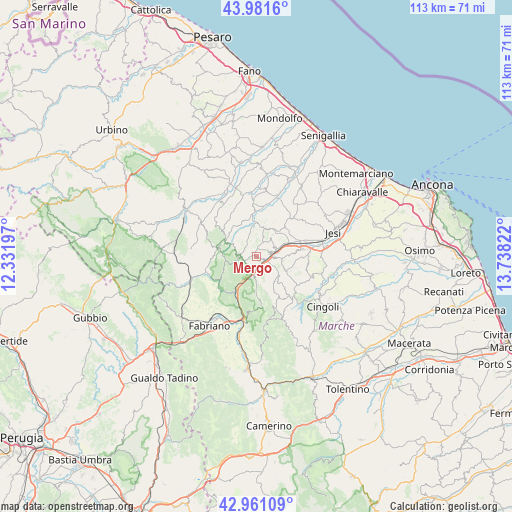
Mergo GPS coordinates[2]
43° 28' 24.6" North, 13° 2' 6.324" East
| Map corner | latitude | longitude |
|---|---|---|
| Upper-left | 43.9816°, | 12.33197° |
| Center: | 43.4735°, | 13.03509° |
| Lower-right: | 42.96109°, | 13.73822° |
| Map W x H: | 113.5×113.5 km | = 70.5×70.5mi |
| max Lat: | 47.04031° ⇑60.1% North |
| Mergo: | 43.4735° |
| min Lat: | ⇓39.9% South 35.50142° |
| min Long | Mergo | max Long |
| 6.69888° | 13.03509° | 18.48682° |
| W 68.6%⇐ | ⇒31.4% E |
Elevation
Elevation of Mergo is 365 m = 1198 ft, and this is 58.3 m = 191 ft above average elevation for this country.
| Max E: |
2085 m = 6841 ft | 32.8% |
| Mergo | 365 m 1198 ft | |
| Avg. | 306.7 m = 1006 ft | |
Min E: |
-4 m = -13 ft | 67.2% |
See also: Italy elevation on elevation.city.
Geographical zone
Mergo is located in North temperate zone (between Tropic of Cancer and the Arctic Circle). Distance of this Northern Tropic circle is 2227.9 km =1384.4 mi to South.| Distance of | km | miles | from Mergo |
|---|---|---|---|
| North Pole | 5173.3 | 3214.5 | to North |
| Arctic Circle | 2567.4 | 1595.3 | to North |
| Tropic Cancer | 2227.9 | 1384.4 | to South |
| Equator | 4833.8 | 3003.6 | to South |


Nearby cities:
15 places around Mergo: (largest is in red/bold)
• Angeli
2.7 km =1.7 mi,  92°
92°
• Angeli Stazione
3.7 km =2.3 mi,  77°
77°
• Angeli di Mergo
1.9 km =1.2 mi,  122°
122°
• Arcevia
7.9 km =4.9 mi,  293°
293°
• Castelplanio
4.4 km =2.7 mi,  58°
58°
• Cupramontana
6.8 km =4.2 mi,  112°
112°
• Macine-Borgo Loreto
4.4 km =2.7 mi,  71°
71°
• Maiolati Spontini
6.9 km =4.3 mi, 87°
• Monte Roberto
8.3 km =5.2 mi, 84°
• Montecarotto
6.6 km =4.1 mi,  22°
22°
• Osteria
8.5 km =5.3 mi,  352°
352°
• Poggio San Marcello
5.2 km =3.2 mi,  36°
36°
• Rosora
2.9 km =1.8 mi, 67°
• Serra San Quirico
3.2 km =2 mi,  198°
198°
• Serra de' Conti
7.6 km =4.7 mi,  0°
0°
Sources, notices
• [Note1] Compared only with cities in Italy existing in our database
• [Src1] Map data: © OpenStreetMap contributors (CC-BY-SA)
• [Src2] Other city data from geonames.org with taken over terms of usage.
• [Src3] Geographical zone / Annual Mean Temperature by Robert A. Rohde @ Wikipedia
