Menaggio geodata
Menaggio (Lombardy) is a seat of a third-order administrative division; located in Italy in Europe/Rome (GMT+2) time zone. With population of 3,178 people, there are 2909 cities with bigger population in this country. Compared to other cities in Italy, 92.4% of cities are located further ↓South; 77.5% of cities are located further →East and 54.3% of cities have higher elevation than Menaggio. Note1


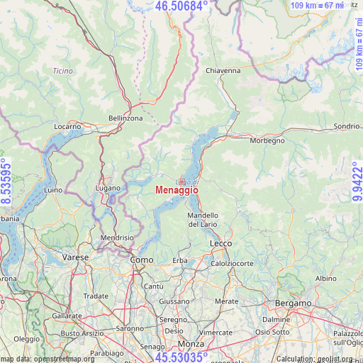
Menaggio GPS coordinates[2]
46° 1' 14.7" North, 9° 14' 20.652" East
| Map corner | latitude | longitude |
|---|---|---|
| Upper-left | 46.50684°, | 8.53595° |
| Center: | 46.02075°, | 9.23907° |
| Lower-right: | 45.53035°, | 9.9422° |
| Map W x H: | 108.6×108.6 km | = 67.5×67.5mi |
| max Lat: | 47.04031° ⇑7.6% North |
| Menaggio: | 46.02075° |
| min Lat: | ⇓92.4% South 35.50142° |
| min Long | Menaggio | max Long |
| 6.69888° | 9.23907° | 18.48682° |
| W 22.5%⇐ | ⇒77.5% E |
Elevation
Elevation of Menaggio is 207 m = 679 ft, and this is 99.7 m = 327 ft below average elevation for this country.
| Max E: |
2085 m = 6841 ft | 54.3% |
| Avg. | 306.7 m = 1006 ft | |
| Menaggio | 207 m = 679 ft | |
Min E: |
-4 m = -13 ft | 45.7% |
See also: Italy elevation on elevation.city.
Geographical zone
Menaggio is located in North temperate zone (between Tropic of Cancer and the Arctic Circle). Distance of this North polar circle is 2284.1 km =1419.3 mi to North.| Distance of | km | miles | from Menaggio |
|---|---|---|---|
| North Pole | 4890 | 3038.5 | to North |
| Arctic Circle | 2284.1 | 1419.3 | to North |
| Tropic Cancer | 2511.1 | 1560.3 | to South |
| Equator | 5117 | 3179.6 | to South |


Nearby cities:
15 places around Menaggio: (largest is in red/bold)
• Azzano
5.2 km =3.2 mi,  212°
212°
• Bellagio
4.1 km =2.5 mi,  154°
154°
• Bellano
5.9 km =3.7 mi,  63°
63°
• Bene Lario
4.3 km =2.7 mi,  282°
282°
• Cadenabbia
3.6 km =2.2 mi,  183°
183°
• Carlazzo
6.2 km =3.9 mi,  292°
292°
• Codogna-Cardano
2.4 km =1.5 mi, 288°
• Grandola ed Uniti
2.1 km =1.3 mi, 282°
• Griante
2.8 km =1.7 mi,  185°
185°
• Mezzegra
5.1 km =3.2 mi, 211°
• Perledo
4.4 km =2.7 mi,  97°
97°
• Plesio
3.1 km =1.9 mi,  345°
345°
• San Siro
5.5 km =3.4 mi,  24°
24°
• Tremezzo
4.4 km =2.7 mi,  203°
203°
• Varenna
3.7 km =2.3 mi,  107°
107°
Sources, notices
• [Note1] Compared only with cities in Italy existing in our database
• [Src1] Map data: © OpenStreetMap contributors (CC-BY-SA)
• [Src2] Other city data from geonames.org with taken over terms of usage.
• [Src3] Geographical zone / Annual Mean Temperature by Robert A. Rohde @ Wikipedia
