Varenna geodata
Varenna (Lombardy) is a seat of a third-order administrative division; located in Italy in Europe/Rome (GMT+2) time zone. With population of 764 people, there are 7855 cities with bigger population in this country. Compared to other cities in Italy, 92.2% of cities are located further ↓South; 76.6% of cities are located further →East and 56.5% of cities have lower elevation than Varenna. Note1


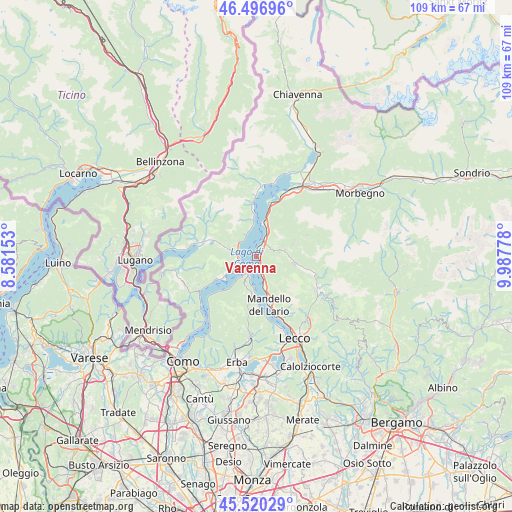
Varenna GPS coordinates[2]
46° 0' 38.808" North, 9° 17' 4.74" East
| Map corner | latitude | longitude |
|---|---|---|
| Upper-left | 46.49696°, | 8.58153° |
| Center: | 46.01078°, | 9.28465° |
| Lower-right: | 45.52029°, | 9.98778° |
| Map W x H: | 108.6×108.6 km | = 67.5×67.5mi |
| max Lat: | 47.04031° ⇑7.8% North |
| Varenna: | 46.01078° |
| min Lat: | ⇓92.2% South 35.50142° |
| min Long | Varenna | max Long |
| 6.69888° | 9.28465° | 18.48682° |
| W 23.4%⇐ | ⇒76.6% E |
Elevation
Elevation of Varenna is 275 m = 902 ft, and this is 31.7 m = 104 ft below average elevation for this country.
| Max E: |
2085 m = 6841 ft | 43.5% |
| Avg. | 306.7 m = 1006 ft | |
| Varenna | 275 m = 902 ft | |
Min E: |
-4 m = -13 ft | 56.5% |
See also: Italy elevation on elevation.city.
Geographical zone
Varenna is located in North temperate zone (between Tropic of Cancer and the Arctic Circle). Distance of this North polar circle is 2285.3 km =1420 mi to North.| Distance of | km | miles | from Varenna |
|---|---|---|---|
| North Pole | 4891.1 | 3039.2 | to North |
| Arctic Circle | 2285.3 | 1420 | to North |
| Tropic Cancer | 2510 | 1559.6 | to South |
| Equator | 5115.9 | 3178.9 | to South |


Nearby cities:
15 places around Varenna: (largest is in red/bold)
• Bellagio
3.1 km =1.9 mi,  214°
214°
• Bellano
4.1 km =2.5 mi,  25°
25°
• Cadenabbia
4.5 km =2.8 mi,  236°
236°
• Codogna-Cardano
6.1 km =3.8 mi,  288°
288°
• Esino Lario
4.2 km =2.6 mi,  115°
115°
• Grandola ed Uniti
5.8 km =3.6 mi, 285°
• Griante
4.2 km =2.6 mi,  245°
245°
• Lierna
6.1 km =3.8 mi,  164°
164°
• Menaggio
3.7 km =2.3 mi, 287°
• Parlasco
4.7 km =2.9 mi,  80°
80°
• Perledo
1 km =0.6 mi,  59°
59°
• Plesio
5.9 km =3.7 mi,  313°
313°
• San Siro
6.2 km =3.9 mi,  348°
348°
• Tremezzo
6.1 km =3.8 mi, 240°
• Vendrogno
4.3 km =2.7 mi,  52°
52°
Sources, notices
• [Note1] Compared only with cities in Italy existing in our database
• [Src1] Map data: © OpenStreetMap contributors (CC-BY-SA)
• [Src2] Other city data from geonames.org with taken over terms of usage.
• [Src3] Geographical zone / Annual Mean Temperature by Robert A. Rohde @ Wikipedia
