Perledo geodata
Perledo (Lombardy) is a seat of a third-order administrative division; located in Italy in Europe/Rome (GMT+2) time zone. With population of 608 people, there are 8934 cities with bigger population in this country. Compared to other cities in Italy, 92.3% of cities are located further ↓South; 76.4% of cities are located further →East and 73.6% of cities have lower elevation than Perledo. Note1


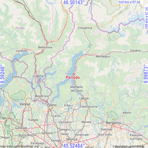
Perledo GPS coordinates[2]
46° 0' 55.044" North, 9° 17' 44.16" East
| Map corner | latitude | longitude |
|---|---|---|
| Upper-left | 46.50143°, | 8.59248° |
| Center: | 46.01529°, | 9.2956° |
| Lower-right: | 45.52484°, | 9.99873° |
| Map W x H: | 108.6×108.6 km | = 67.5×67.5mi |
| max Lat: | 47.04031° ⇑7.7% North |
| Perledo: | 46.01529° |
| min Lat: | ⇓92.3% South 35.50142° |
| min Long | Perledo | max Long |
| 6.69888° | 9.2956° | 18.48682° |
| W 23.6%⇐ | ⇒76.4% E |
Elevation
Elevation of Perledo is 433 m = 1421 ft, and this is 126.3 m = 414 ft above average elevation for this country.
| Max E: |
2085 m = 6841 ft | 26.4% |
| Perledo | 433 m 1421 ft | |
| Avg. | 306.7 m = 1006 ft | |
Min E: |
-4 m = -13 ft | 73.6% |
See also: Italy elevation on elevation.city.
Geographical zone
Perledo is located in North temperate zone (between Tropic of Cancer and the Arctic Circle). Distance of this North polar circle is 2284.8 km =1419.7 mi to North.| Distance of | km | miles | from Perledo |
|---|---|---|---|
| North Pole | 4890.6 | 3038.9 | to North |
| Arctic Circle | 2284.8 | 1419.7 | to North |
| Tropic Cancer | 2510.5 | 1560 | to South |
| Equator | 5116.4 | 3179.2 | to South |


Nearby cities:
15 places around Perledo: (largest is in red/bold)
• Bellagio
4 km =2.5 mi,  220°
220°
• Bellano
3.3 km =2.1 mi,  15°
15°
• Cadenabbia
5.5 km =3.4 mi,  237°
237°
• Crandola Valsassina
6.5 km =4 mi,  82°
82°
• Esino Lario
3.8 km =2.4 mi,  128°
128°
• Grandola ed Uniti
6.5 km =4 mi,  279°
279°
• Griante
5.1 km =3.2 mi, 244°
• Lierna
6.4 km =4 mi,  173°
173°
• Menaggio
4.4 km =2.7 mi, 277°
• Parlasco
3.8 km =2.4 mi,  85°
85°
• Plesio
6.3 km =3.9 mi,  304°
304°
• San Siro
6 km =3.7 mi,  339°
339°
• Taceno
5.3 km =3.3 mi, 81°
• Varenna
1 km =0.6 mi, 239°
• Vendrogno
3.4 km =2.1 mi,  50°
50°
Sources, notices
• [Note1] Compared only with cities in Italy existing in our database
• [Src1] Map data: © OpenStreetMap contributors (CC-BY-SA)
• [Src2] Other city data from geonames.org with taken over terms of usage.
• [Src3] Geographical zone / Annual Mean Temperature by Robert A. Rohde @ Wikipedia
