Ramiola geodata
Ramiola (Emilia-Romagna) is a populated place; located in Italy in Europe/Rome (GMT+2) time zone. With population of 1,496 people, there are 5125 cities with bigger population in this country. Compared to other cities in Italy, 54.3% of cities are located further ↓South; 67% of cities are located further →East and 60.9% of cities have higher elevation than Ramiola. Note1


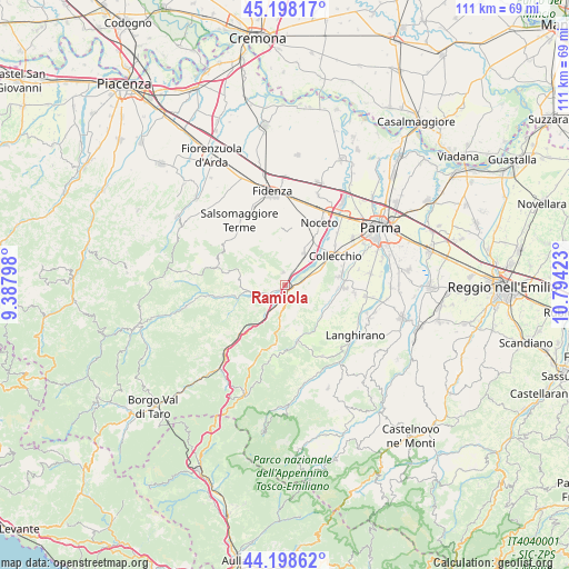
Ramiola GPS coordinates[2]
44° 42' 1.98" North, 10° 5' 27.96" East
| Map corner | latitude | longitude |
|---|---|---|
| Upper-left | 45.19817°, | 9.38798° |
| Center: | 44.70055°, | 10.0911° |
| Lower-right: | 44.19862°, | 10.79423° |
| Map W x H: | 111.1×111.1 km | = 69×69mi |
| max Lat: | 47.04031° ⇑45.7% North |
| Ramiola: | 44.70055° |
| min Lat: | ⇓54.3% South 35.50142° |
| min Long | Ramiola | max Long |
| 6.69888° | 10.0911° | 18.48682° |
| W 33%⇐ | ⇒67% E |
Elevation
Elevation of Ramiola is 156 m = 512 ft, and this is 150.7 m = 494 ft below average elevation for this country.
| Max E: |
2085 m = 6841 ft | 60.9% |
| Avg. | 306.7 m = 1006 ft | |
| Ramiola | 156 m = 512 ft | |
Min E: |
-4 m = -13 ft | 39.1% |
See also: Italy elevation on elevation.city.
Geographical zone
Ramiola is located in North temperate zone (between Tropic of Cancer and the Arctic Circle). Distance of this Northern Tropic circle is 2364.3 km =1469.1 mi to South.| Distance of | km | miles | from Ramiola |
|---|---|---|---|
| North Pole | 5036.8 | 3129.7 | to North |
| Arctic Circle | 2430.9 | 1510.5 | to North |
| Tropic Cancer | 2364.3 | 1469.1 | to South |
| Equator | 4970.2 | 3088.3 | to South |


Nearby cities:
15 places around Ramiola: (largest is in red/bold)
• Calestano
11.2 km =7 mi,  166°
166°
• Collecchio
11.4 km =7.1 mi,  59°
59°
• Felegara
2.9 km =1.8 mi,  35°
35°
• Felino
11.6 km =7.2 mi,  90°
90°
• Fornovo di Taro
1.1 km =0.7 mi,  127°
127°
• Gaiano
6.9 km =4.3 mi,  68°
68°
• Marzolara
9.9 km =6.2 mi,  139°
139°
• Medesano
7.4 km =4.6 mi,  29°
29°
• Ozzano Taro
4.1 km =2.5 mi,  75°
75°
• Riccò
2.4 km =1.5 mi, 90°
• Sala Baganza
10.8 km =6.7 mi, 81°
• Salita-Riola
2.8 km =1.7 mi, 170°
• Sant'Andrea Bagni
2.5 km =1.6 mi,  355°
355°
• Terenzo
10 km =6.2 mi,  180°
180°
• Varano De' Melegari
6.4 km =4 mi,  257°
257°
Sources, notices
• [Note1] Compared only with cities in Italy existing in our database
• [Src1] Map data: © OpenStreetMap contributors (CC-BY-SA)
• [Src2] Other city data from geonames.org with taken over terms of usage.
• [Src3] Geographical zone / Annual Mean Temperature by Robert A. Rohde @ Wikipedia
