Fornovo di Taro geodata
Fornovo di Taro (Emilia-Romagna) is a seat of a third-order administrative division; located in Italy in Europe/Rome (GMT+2) time zone. With population of 3,029 people, there are 3016 cities with bigger population in this country. Compared to other cities in Italy, 54.2% of cities are located further ↓South; 66.9% of cities are located further →East and 63.7% of cities have higher elevation than Fornovo di Taro. Note1
Administrative division(s):
- Level 1: Emilia-Romagna
- Level 2: Provincia di Parma
- Level 3: Fornovo di Taro


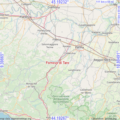
Fornovo di Taro GPS coordinates[2]
44° 41' 40.74" North, 10° 6' 6.408" East
| Map corner | latitude | longitude |
|---|---|---|
| Upper-left | 45.19232°, | 9.39865° |
| Center: | 44.69465°, | 10.10178° |
| Lower-right: | 44.19267°, | 10.80491° |
| Map W x H: | 111.2×111.2 km | = 69.1×69.1mi |
| max Lat: | 47.04031° ⇑45.8% North |
| Fornovo di Taro: | 44.69465° |
| min Lat: | ⇓54.2% South 35.50142° |
| min Long | Fornovo di Taro | max Long |
| 6.69888° | 10.10178° | 18.48682° |
| W 33.1%⇐ | ⇒66.9% E |
Elevation
Elevation of Fornovo di Taro is 136 m = 446 ft, and this is 170.7 m = 560 ft below average elevation for this country.
| Max E: |
2085 m = 6841 ft | 63.7% |
| Avg. | 306.7 m = 1006 ft | |
| Fornovo di Taro | 136 m = 446 ft | |
Min E: |
-4 m = -13 ft | 36.3% |
See also: Italy elevation on elevation.city.
Geographical zone
Fornovo di Taro is located in North temperate zone (between Tropic of Cancer and the Arctic Circle). Distance of this Northern Tropic circle is 2363.7 km =1468.7 mi to South.| Distance of | km | miles | from Fornovo di Taro |
|---|---|---|---|
| North Pole | 5037.5 | 3130.2 | to North |
| Arctic Circle | 2431.6 | 1510.9 | to North |
| Tropic Cancer | 2363.7 | 1468.7 | to South |
| Equator | 4969.6 | 3088 | to South |


Nearby cities:
15 places around Fornovo di Taro: (largest is in red/bold)
• Calestano
10.4 km =6.5 mi,  170°
170°
• Collecchio
11 km =6.8 mi,  54°
54°
• Felegara
3.1 km =1.9 mi,  15°
15°
• Felino
10.8 km =6.7 mi,  87°
87°
• Gaiano
6.5 km =4 mi,  59°
59°
• Marzolara
8.9 km =5.5 mi,  140°
140°
• Medesano
7.6 km =4.7 mi, 21°
• Ozzano Taro
3.5 km =2.2 mi, 61°
• Ramiola
1.1 km =0.7 mi,  307°
307°
• Riccò
1.6 km =1 mi,  66°
66°
• Sala Baganza
10.1 km =6.3 mi,  76°
76°
• Salita-Riola
2.2 km =1.4 mi,  189°
189°
• Sant'Andrea Bagni
3.3 km =2.1 mi,  341°
341°
• Terenzo
9.4 km =5.8 mi, 185°
• Varano De' Melegari
7.2 km =4.5 mi,  264°
264°
Sources, notices
• [Note1] Compared only with cities in Italy existing in our database
• [Src1] Map data: © OpenStreetMap contributors (CC-BY-SA)
• [Src2] Other city data from geonames.org with taken over terms of usage.
• [Src3] Geographical zone / Annual Mean Temperature by Robert A. Rohde @ Wikipedia
