Salita-Riola geodata
Salita-Riola (Emilia-Romagna) is a populated place; located in Italy in Europe/Rome (GMT+2) time zone. With population of 504 people, there are 9889 cities with bigger population in this country. Compared to other cities in Italy, 53.8% of cities are located further ↓South; 66.9% of cities are located further →East and 61.2% of cities have higher elevation than Salita-Riola. Note1
Administrative division(s):
- Level 1: Emilia-Romagna
- Level 2: Provincia di Parma
- Level 3: Fornovo di Taro


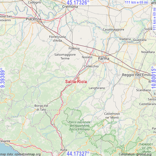
Salita-Riola GPS coordinates[2]
44° 40' 31.512" North, 10° 5' 49.272" East
| Map corner | latitude | longitude |
|---|---|---|
| Upper-left | 45.17326°, | 9.39389° |
| Center: | 44.67542°, | 10.09702° |
| Lower-right: | 44.17327°, | 10.80015° |
| Map W x H: | 111.2×111.2 km | = 69.1×69.1mi |
| max Lat: | 47.04031° ⇑46.2% North |
| Salita-Riola: | 44.67542° |
| min Lat: | ⇓53.8% South 35.50142° |
| min Long | Salita-Riola | max Long |
| 6.69888° | 10.09702° | 18.48682° |
| W 33.1%⇐ | ⇒66.9% E |
Elevation
Elevation of Salita-Riola is 154 m = 505 ft, and this is 152.7 m = 501 ft below average elevation for this country.
| Max E: |
2085 m = 6841 ft | 61.2% |
| Avg. | 306.7 m = 1006 ft | |
| Salita-Riola | 154 m = 505 ft | |
Min E: |
-4 m = -13 ft | 38.8% |
See also: Italy elevation on elevation.city.
Geographical zone
Salita-Riola is located in North temperate zone (between Tropic of Cancer and the Arctic Circle). Distance of this Northern Tropic circle is 2361.5 km =1467.4 mi to South.| Distance of | km | miles | from Salita-Riola |
|---|---|---|---|
| North Pole | 5039.6 | 3131.5 | to North |
| Arctic Circle | 2433.7 | 1512.2 | to North |
| Tropic Cancer | 2361.5 | 1467.4 | to South |
| Equator | 4967.4 | 3086.6 | to South |


Nearby cities:
15 places around Salita-Riola: (largest is in red/bold)
• Calestano
8.4 km =5.2 mi,  165°
165°
• Felegara
5.3 km =3.3 mi,  13°
13°
• Felino
11.5 km =7.1 mi,  76°
76°
• Fornovo di Taro
2.2 km =1.4 mi, 9°
• Gaiano
8.1 km =5 mi,  47°
47°
• Marzolara
7.6 km =4.7 mi,  128°
128°
• Medesano
9.8 km =6.1 mi,  19°
19°
• Ozzano Taro
5.2 km =3.2 mi,  42°
42°
• Ramiola
2.8 km =1.7 mi,  350°
350°
• Riccò
3.4 km =2.1 mi,  34°
34°
• Sala Baganza
11.1 km =6.9 mi,  66°
66°
• Sant'Andrea Bagni
5.3 km =3.3 mi, 352°
• Solignano
11.9 km =7.4 mi,  234°
234°
• Terenzo
7.2 km =4.5 mi,  184°
184°
• Varano De' Melegari
6.9 km =4.3 mi,  281°
281°
Sources, notices
• [Note1] Compared only with cities in Italy existing in our database
• [Src1] Map data: © OpenStreetMap contributors (CC-BY-SA)
• [Src2] Other city data from geonames.org with taken over terms of usage.
• [Src3] Geographical zone / Annual Mean Temperature by Robert A. Rohde @ Wikipedia
