Massa d'Albe-Corona geodata
Massa d'Albe-Corona (Abruzzo) is a seat of a third-order administrative division; located in Italy in Europe/Rome (GMT+2) time zone. With population of 599 people, there are 9016 cities with bigger population in this country. Compared to other cities in Italy, 69.4% of cities are located further ↑North; 72.3% of cities are located further ←West and 94.5% of cities have lower elevation than Massa d'Albe-Corona. Note1


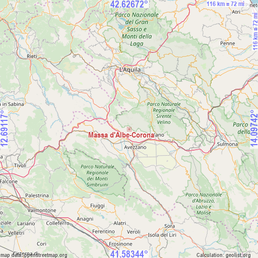
Massa d'Albe-Corona GPS coordinates[2]
42° 6' 26.028" North, 13° 23' 39.444" East
| Map corner | latitude | longitude |
|---|---|---|
| Upper-left | 42.62672°, | 12.69117° |
| Center: | 42.10723°, | 13.39429° |
| Lower-right: | 41.58344°, | 14.09742° |
| Map W x H: | 116×116 km | = 72.1×72.1mi |
| max Lat: | 47.04031° ⇑69.4% North |
| Massa d'Albe-Corona: | 42.10723° |
| min Lat: | ⇓30.6% South 35.50142° |
| min Long | Massa d'Albe-Co | max Long |
| 6.69888° | 13.39429° | 18.48682° |
| W 72.3%⇐ | ⇒27.7% E |
Elevation
Elevation of Massa d'Albe-Corona is 855 m = 2805 ft, and this is 548.3 m = 1799 ft above average elevation for this country.
| Max E: |
2085 m = 6841 ft | 5.5% |
| Massa d'Albe-Corona | 855 m 2805 ft | |
| Avg. | 306.7 m = 1006 ft | |
Min E: |
-4 m = -13 ft | 94.5% |
See also: Italy elevation on elevation.city.
Geographical zone
Massa d'Albe-Corona is located in North temperate zone (between Tropic of Cancer and the Arctic Circle). Distance of this Northern Tropic circle is 2076 km =1290 mi to South.| Distance of | km | miles | from Massa d'Albe-Corona |
|---|---|---|---|
| North Pole | 5325.2 | 3308.9 | to North |
| Arctic Circle | 2719.3 | 1689.7 | to North |
| Tropic Cancer | 2076 | 1290 | to South |
| Equator | 4681.9 | 2909.2 | to South |


Nearby cities:
15 places around Massa d'Albe-Corona: (largest is in red/bold)
• Antrosano
5 km =3.1 mi,  164°
164°
• Avezzano
9.1 km =5.7 mi, 163°
• Capistrello
15 km =9.3 mi,  179°
179°
• Cappadocia
14.7 km =9.1 mi,  220°
220°
• Cappelle
4.6 km =2.9 mi,  194°
194°
• Castellafiume
14 km =8.7 mi,  200°
200°
• Celano
10.5 km =6.5 mi,  106°
106°
• Cese
9.2 km =5.7 mi, 182°
• Corvaro
15.3 km =9.5 mi,  315°
315°
• Magliano De'Marsi
3.1 km =1.9 mi,  235°
235°
• Ovindoli
10.6 km =6.6 mi,  71°
71°
• Rocca di Mezzo
14.9 km =9.3 mi,  43°
43°
• Scurcola Marsicana
6.7 km =4.2 mi, 222°
• Tagliacozzo
12.3 km =7.6 mi,  249°
249°
• Torano
12.2 km =7.6 mi,  294°
294°
Sources, notices
• [Note1] Compared only with cities in Italy existing in our database
• [Src1] Map data: © OpenStreetMap contributors (CC-BY-SA)
• [Src2] Other city data from geonames.org with taken over terms of usage.
• [Src3] Geographical zone / Annual Mean Temperature by Robert A. Rohde @ Wikipedia
