Cappadocia geodata
Cappadocia (Abruzzo) is a seat of a third-order administrative division; located in Italy in Europe/Rome (GMT+2) time zone. With population of 243 people, there are 10928 cities with bigger population in this country. Compared to other cities in Italy, 70.2% of cities are located further ↑North; 71.2% of cities are located further ←West and 98% of cities have lower elevation than Cappadocia. Note1


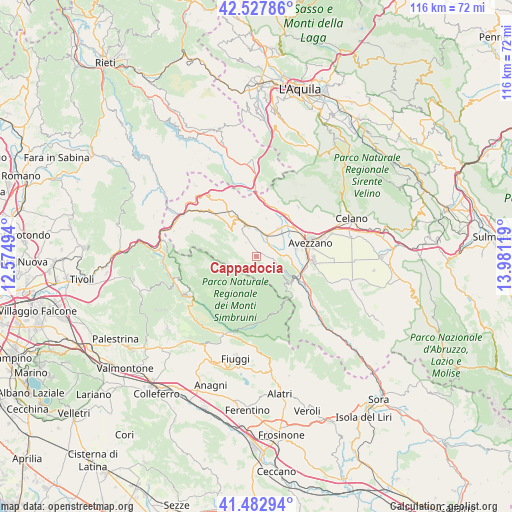
Cappadocia GPS coordinates[2]
42° 0' 27.18" North, 13° 16' 41.016" East
| Map corner | latitude | longitude |
|---|---|---|
| Upper-left | 42.52786°, | 12.57494° |
| Center: | 42.00755°, | 13.27806° |
| Lower-right: | 41.48294°, | 13.98119° |
| Map W x H: | 116.2×116.2 km | = 72.2×72.2mi |
| max Lat: | 47.04031° ⇑70.2% North |
| Cappadocia: | 42.00755° |
| min Lat: | ⇓29.8% South 35.50142° |
| min Long | Cappadocia | max Long |
| 6.69888° | 13.27806° | 18.48682° |
| W 71.2%⇐ | ⇒28.8% E |
Elevation
Elevation of Cappadocia is 1099 m = 3606 ft, and this is 792.3 m = 2599 ft above average elevation for this country.
| Max E: |
2085 m = 6841 ft | 2% |
| Cappadocia | 1099 m 3606 ft | |
| Avg. | 306.7 m = 1006 ft | |
Min E: |
-4 m = -13 ft | 98% |
See also: Italy elevation on elevation.city.
Geographical zone
Cappadocia is located in North temperate zone (between Tropic of Cancer and the Arctic Circle). Distance of this Northern Tropic circle is 2064.9 km =1283.1 mi to South.| Distance of | km | miles | from Cappadocia |
|---|---|---|---|
| North Pole | 5336.3 | 3315.8 | to North |
| Arctic Circle | 2730.4 | 1696.6 | to North |
| Tropic Cancer | 2064.9 | 1283.1 | to South |
| Equator | 4670.8 | 2902.3 | to South |


Nearby cities:
15 places around Cappadocia: (largest is in red/bold)
• Antrosano
12.6 km =7.8 mi,  60°
60°
• Avezzano
12.5 km =7.8 mi,  79°
79°
• Camerata Nuova
14 km =8.7 mi,  274°
274°
• Canistro Inferiore
13.3 km =8.3 mi,  123°
123°
• Capistrello
10.5 km =6.5 mi,  111°
111°
• Cappelle
10.7 km =6.6 mi,  51°
51°
• Castellafiume
5.1 km =3.2 mi, 113°
• Cese
9.3 km =5.8 mi, 78°
• Filettino
13.5 km =8.4 mi,  163°
163°
• Magliano De'Marsi
11.7 km =7.3 mi,  37°
37°
• Massa d'Albe-Corona
14.7 km =9.1 mi, 40°
• Sante Marie
12.4 km =7.7 mi,  329°
329°
• Scurcola Marsicana
8 km =5 mi, 39°
• Tagliacozzo
7.1 km =4.4 mi,  344°
344°
• Vallepietra
9.9 km =6.2 mi,  202°
202°
Sources, notices
• [Note1] Compared only with cities in Italy existing in our database
• [Src1] Map data: © OpenStreetMap contributors (CC-BY-SA)
• [Src2] Other city data from geonames.org with taken over terms of usage.
• [Src3] Geographical zone / Annual Mean Temperature by Robert A. Rohde @ Wikipedia
