Cappelle geodata
Cappelle (Abruzzo) is a populated place; located in Italy in Europe/Rome (GMT+2) time zone. With population of 910 people, there are 7091 cities with bigger population in this country. Compared to other cities in Italy, 69.7% of cities are located further ↑North; 72.2% of cities are located further ←West and 89.6% of cities have lower elevation than Cappelle. Note1
Administrative division(s):
- Level 1: Abruzzo
- Level 2: Provincia dell' Aquila
- Level 3: Scurcola Marsicana


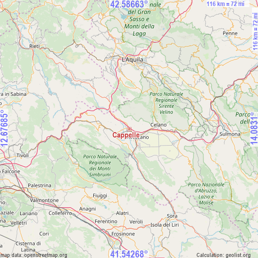
Cappelle GPS coordinates[2]
42° 4' 0.48" North, 13° 22' 47.892" East
| Map corner | latitude | longitude |
|---|---|---|
| Upper-left | 42.58663°, | 12.67685° |
| Center: | 42.0668°, | 13.37997° |
| Lower-right: | 41.54268°, | 14.0831° |
| Map W x H: | 116.1×116.1 km | = 72.1×72.1mi |
| max Lat: | 47.04031° ⇑69.7% North |
| Cappelle: | 42.0668° |
| min Lat: | ⇓30.3% South 35.50142° |
| min Long | Cappelle | max Long |
| 6.69888° | 13.37997° | 18.48682° |
| W 72.2%⇐ | ⇒27.8% E |
Elevation
Elevation of Cappelle is 711 m = 2333 ft, and this is 404.3 m = 1326 ft above average elevation for this country.
| Max E: |
2085 m = 6841 ft | 10.4% |
| Cappelle | 711 m 2333 ft | |
| Avg. | 306.7 m = 1006 ft | |
Min E: |
-4 m = -13 ft | 89.6% |
See also: Italy elevation on elevation.city.
Geographical zone
Cappelle is located in North temperate zone (between Tropic of Cancer and the Arctic Circle). Distance of this Northern Tropic circle is 2071.5 km =1287.2 mi to South.| Distance of | km | miles | from Cappelle |
|---|---|---|---|
| North Pole | 5329.7 | 3311.7 | to North |
| Arctic Circle | 2723.8 | 1692.5 | to North |
| Tropic Cancer | 2071.5 | 1287.2 | to South |
| Equator | 4677.4 | 2906.4 | to South |


Nearby cities:
15 places around Cappelle: (largest is in red/bold)
• Antrosano
2.5 km =1.6 mi,  96°
96°
• Avezzano
5.7 km =3.5 mi,  137°
137°
• Canistro Inferiore
14.2 km =8.8 mi,  169°
169°
• Capistrello
10.6 km =6.6 mi, 172°
• Cappadocia
10.7 km =6.6 mi,  231°
231°
• Castellafiume
9.4 km =5.8 mi,  203°
203°
• Celano
11.4 km =7.1 mi,  82°
82°
• Cese
4.8 km =3 mi, 171°
• Luco dei Marsi
14.2 km =8.8 mi,  147°
147°
• Magliano De'Marsi
3.1 km =1.9 mi,  334°
334°
• Massa d'Albe-Corona
4.6 km =2.9 mi,  14°
14°
• Ovindoli
13.7 km =8.5 mi,  54°
54°
• Scurcola Marsicana
3.4 km =2.1 mi,  263°
263°
• Tagliacozzo
10.3 km =6.4 mi,  271°
271°
• Torano
13.8 km =8.6 mi,  314°
314°
Sources, notices
• [Note1] Compared only with cities in Italy existing in our database
• [Src1] Map data: © OpenStreetMap contributors (CC-BY-SA)
• [Src2] Other city data from geonames.org with taken over terms of usage.
• [Src3] Geographical zone / Annual Mean Temperature by Robert A. Rohde @ Wikipedia
