Marzolara geodata
Marzolara (Emilia-Romagna) is a populated place; located in Italy in Europe/Rome (GMT+2) time zone. With population of 535 people, there are 9594 cities with bigger population in this country. Compared to other cities in Italy, 53.1% of cities are located further ↓South; 66.3% of cities are located further →East and 63% of cities have lower elevation than Marzolara. Note1


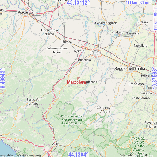
Marzolara GPS coordinates[2]
44° 37' 58.512" North, 10° 10' 21.18" East
| Map corner | latitude | longitude |
|---|---|---|
| Upper-left | 45.13112°, | 9.46943° |
| Center: | 44.63292°, | 10.17255° |
| Lower-right: | 44.1304°, | 10.87568° |
| Map W x H: | 111.3×111.3 km | = 69.2×69.2mi |
| max Lat: | 47.04031° ⇑46.9% North |
| Marzolara: | 44.63292° |
| min Lat: | ⇓53.1% South 35.50142° |
| min Long | Marzolara | max Long |
| 6.69888° | 10.17255° | 18.48682° |
| W 33.7%⇐ | ⇒66.3% E |
Elevation
Elevation of Marzolara is 323 m = 1060 ft, and this is 16.3 m = 53 ft above average elevation for this country.
| Max E: |
2085 m = 6841 ft | 37% |
| Marzolara | 323 m 1060 ft | |
| Avg. | 306.7 m = 1006 ft | |
Min E: |
-4 m = -13 ft | 63% |
See also: Italy elevation on elevation.city.
Geographical zone
Marzolara is located in North temperate zone (between Tropic of Cancer and the Arctic Circle). Distance of this Northern Tropic circle is 2356.8 km =1464.4 mi to South.| Distance of | km | miles | from Marzolara |
|---|---|---|---|
| North Pole | 5044.3 | 3134.4 | to North |
| Arctic Circle | 2438.5 | 1515.2 | to North |
| Tropic Cancer | 2356.8 | 1464.4 | to South |
| Equator | 4962.7 | 3083.7 | to South |


Nearby cities:
15 places around Marzolara: (largest is in red/bold)
• Calestano
5.2 km =3.2 mi,  228°
228°
• Felino
9 km =5.6 mi,  35°
35°
• Fornovo di Taro
8.9 km =5.5 mi,  320°
320°
• Gaiano
10.1 km =6.3 mi,  0°
0°
• Langhirano
7.6 km =4.7 mi,  101°
101°
• Lesignano de'Bagni
10.2 km =6.3 mi,  83°
83°
• Mulazzano Ponte
8.3 km =5.2 mi,  114°
114°
• Ozzano Taro
8.9 km =5.5 mi,  343°
343°
• Pilastro
10.7 km =6.6 mi,  59°
59°
• Ramiola
9.9 km =6.2 mi, 319°
• Riccò
8.6 km =5.3 mi,  331°
331°
• Sala Baganza
10.1 km =6.3 mi,  24°
24°
• Salita-Riola
7.6 km =4.7 mi,  308°
308°
• San Michele Tiorre
9.2 km =5.7 mi,  50°
50°
• Terenzo
7 km =4.3 mi,  249°
249°
Sources, notices
• [Note1] Compared only with cities in Italy existing in our database
• [Src1] Map data: © OpenStreetMap contributors (CC-BY-SA)
• [Src2] Other city data from geonames.org with taken over terms of usage.
• [Src3] Geographical zone / Annual Mean Temperature by Robert A. Rohde @ Wikipedia
