Corrubbio geodata
Corrubbio (Veneto) is a populated place; located in Italy in Europe/Rome (GMT+2) time zone. With population of 1,685 people, there are 4697 cities with bigger population in this country. Compared to other cities in Italy, 73.2% of cities are located further ↓South; 58.5% of cities are located further →East and 68% of cities have higher elevation than Corrubbio. Note1
Administrative division(s):
- Level 1: Veneto
- Level 2: Provincia di Verona
- Level 3: San Pietro in Cariano


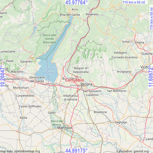
Corrubbio GPS coordinates[2]
45° 29' 12.66" North, 10° 54' 12.924" East
| Map corner | latitude | longitude |
|---|---|---|
| Upper-left | 45.97764°, | 10.20047° |
| Center: | 45.48685°, | 10.90359° |
| Lower-right: | 44.99175°, | 11.60672° |
| Map W x H: | 109.6×109.6 km | = 68.1×68.1mi |
| max Lat: | 47.04031° ⇑26.8% North |
| Corrubbio: | 45.48685° |
| min Lat: | ⇓73.2% South 35.50142° |
| min Long | Corrubbio | max Long |
| 6.69888° | 10.90359° | 18.48682° |
| W 41.5%⇐ | ⇒58.5% E |
Elevation
Elevation of Corrubbio is 109 m = 358 ft, and this is 197.7 m = 649 ft below average elevation for this country.
| Max E: |
2085 m = 6841 ft | 68% |
| Avg. | 306.7 m = 1006 ft | |
| Corrubbio | 109 m = 358 ft | |
Min E: |
-4 m = -13 ft | 32% |
See also: Italy elevation on elevation.city.
Geographical zone
Corrubbio is located in North temperate zone (between Tropic of Cancer and the Arctic Circle). Distance of this North polar circle is 2343.5 km =1456.2 mi to North.| Distance of | km | miles | from Corrubbio |
|---|---|---|---|
| North Pole | 4949.4 | 3075.4 | to North |
| Arctic Circle | 2343.5 | 1456.2 | to North |
| Tropic Cancer | 2451.7 | 1523.4 | to South |
| Equator | 5057.7 | 3142.7 | to South |


Nearby cities:
15 places around Corrubbio: (largest is in red/bold)
• Arbizzano-Santa Maria
2.9 km =1.8 mi,  71°
71°
• Bassone
4 km =2.5 mi,  190°
190°
• Bure
5.1 km =3.2 mi,  330°
330°
• Bussolengo
4.4 km =2.7 mi,  243°
243°
• Montericco
4.2 km =2.6 mi,  81°
81°
• Negrar
5.5 km =3.4 mi,  30°
30°
• Ospedaletto
5.2 km =3.2 mi,  292°
292°
• Parona
3.3 km =2.1 mi,  105°
105°
• Pedemonte
2.1 km =1.3 mi, 33°
• Pescantina
2.8 km =1.7 mi,  266°
266°
• San Floriano
3.5 km =2.2 mi,  5°
5°
• San Pietro in Cariano
3.7 km =2.3 mi,  338°
338°
• San Vito al Mantico
1.9 km =1.2 mi,  207°
207°
• Settimo
0.9 km =0.6 mi,  152°
152°
• Valgatara
5.4 km =3.4 mi, 6°
Sources, notices
• [Note1] Compared only with cities in Italy existing in our database
• [Src1] Map data: © OpenStreetMap contributors (CC-BY-SA)
• [Src2] Other city data from geonames.org with taken over terms of usage.
• [Src3] Geographical zone / Annual Mean Temperature by Robert A. Rohde @ Wikipedia
