Limbiate geodata
Limbiate (Lombardy) is a seat of a third-order administrative division; located in Italy in Europe/Rome (GMT+2) time zone. With population of 32,062 people, there are 252 cities with bigger population in this country. Compared to other cities in Italy, 77.1% of cities are located further ↓South; 79.2% of cities are located further →East and 57.6% of cities have higher elevation than Limbiate. Note1
Administrative division(s):
- Level 1: Lombardy
- Level 2: Provincia di Monza e della Brianza
- Level 3: Limbiate


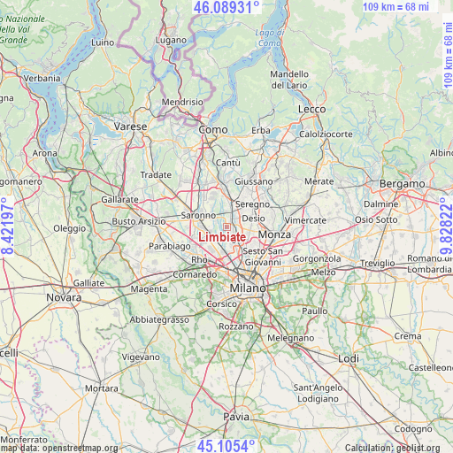
Limbiate GPS coordinates[2]
45° 35' 58.236" North, 9° 7' 30.324" East
| Map corner | latitude | longitude |
|---|---|---|
| Upper-left | 46.08931°, | 8.42197° |
| Center: | 45.59951°, | 9.12509° |
| Lower-right: | 45.1054°, | 9.82822° |
| Map W x H: | 109.4×109.4 km | = 68×68mi |
| max Lat: | 47.04031° ⇑22.9% North |
| Limbiate: | 45.59951° |
| min Lat: | ⇓77.1% South 35.50142° |
| min Long | Limbiate | max Long |
| 6.69888° | 9.12509° | 18.48682° |
| W 20.8%⇐ | ⇒79.2% E |
Elevation
Elevation of Limbiate is 183 m = 600 ft, and this is 123.7 m = 406 ft below average elevation for this country.
| Max E: |
2085 m = 6841 ft | 57.6% |
| Avg. | 306.7 m = 1006 ft | |
| Limbiate | 183 m = 600 ft | |
Min E: |
-4 m = -13 ft | 42.4% |
See also: Italy elevation on elevation.city.
Geographical zone
Limbiate is located in North temperate zone (between Tropic of Cancer and the Arctic Circle). Distance of this North polar circle is 2331 km =1448.4 mi to North.| Distance of | km | miles | from Limbiate |
|---|---|---|---|
| North Pole | 4936.9 | 3067.6 | to North |
| Arctic Circle | 2331 | 1448.4 | to North |
| Tropic Cancer | 2464.3 | 1531.2 | to South |
| Equator | 5070.2 | 3150.5 | to South |


Nearby cities:
15 places around Limbiate: (largest is in red/bold)
• Barlassina
6.2 km =3.9 mi,  2°
2°
• Bollate
5.9 km =3.7 mi,  183°
183°
• Bovisio-Masciago
2.5 km =1.6 mi,  61°
61°
• Caronno Pertusella
6.1 km =3.8 mi,  268°
268°
• Ceriano Laghetto
4.8 km =3 mi,  313°
313°
• Cesano Maderno
3.9 km =2.4 mi,  32°
32°
• Cesate
3.9 km =2.4 mi,  263°
263°
• Garbagnate Milanese
4.8 km =3 mi,  234°
234°
• Nova Milanese
5.8 km =3.6 mi,  101°
101°
• Paderno Dugnano
4.6 km =2.9 mi,  137°
137°
• Senago
2.7 km =1.7 mi, 178°
• Seveso
5.4 km =3.4 mi,  14°
14°
• Solaro
3.7 km =2.3 mi,  296°
296°
• Varedo
3 km =1.9 mi,  94°
94°
• Villaggio del Sole
2.1 km =1.3 mi,  319°
319°
Sources, notices
• [Note1] Compared only with cities in Italy existing in our database
• [Src1] Map data: © OpenStreetMap contributors (CC-BY-SA)
• [Src2] Other city data from geonames.org with taken over terms of usage.
• [Src3] Geographical zone / Annual Mean Temperature by Robert A. Rohde @ Wikipedia
