Caronno Pertusella geodata
Caronno Pertusella (Lombardy) is a seat of a third-order administrative division; located in Italy in Europe/Rome (GMT+2) time zone. With population of 16,377 people, there are 555 cities with bigger population in this country. Compared to other cities in Italy, 77% of cities are located further ↓South; 80.6% of cities are located further →East and 55.9% of cities have higher elevation than Caronno Pertusella. Note1
Administrative division(s):
- Level 1: Lombardy
- Level 2: Provincia di Varese
- Level 3: Caronno Pertusella


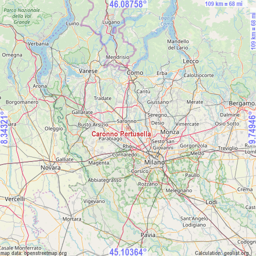
Caronno Pertusella GPS coordinates[2]
45° 35' 51.972" North, 9° 2' 46.824" East
| Map corner | latitude | longitude |
|---|---|---|
| Upper-left | 46.08758°, | 8.34321° |
| Center: | 45.59777°, | 9.04634° |
| Lower-right: | 45.10364°, | 9.74946° |
| Map W x H: | 109.4×109.4 km | = 68×68mi |
| max Lat: | 47.04031° ⇑23% North |
| Caronno Pertusella: | 45.59777° |
| min Lat: | ⇓77% South 35.50142° |
| min Long | Caronno Pertuse | max Long |
| 6.69888° | 9.04634° | 18.48682° |
| W 19.4%⇐ | ⇒80.6% E |
Elevation
Elevation of Caronno Pertusella is 196 m = 643 ft, and this is 110.7 m = 363 ft below average elevation for this country.
| Max E: |
2085 m = 6841 ft | 55.9% |
| Avg. | 306.7 m = 1006 ft | |
| Caronno Pertusella | 196 m = 643 ft | |
Min E: |
-4 m = -13 ft | 44.1% |
See also: Italy elevation on elevation.city.
Geographical zone
Caronno Pertusella is located in North temperate zone (between Tropic of Cancer and the Arctic Circle). Distance of this North polar circle is 2331.2 km =1448.5 mi to North.| Distance of | km | miles | from Caronno Pertusella |
|---|---|---|---|
| North Pole | 4937.1 | 3067.8 | to North |
| Arctic Circle | 2331.2 | 1448.5 | to North |
| Tropic Cancer | 2464.1 | 1531.1 | to South |
| Equator | 5070 | 3150.4 | to South |


Nearby cities:
15 places around Caronno Pertusella: (largest is in red/bold)
• Arese
5.8 km =3.6 mi,  155°
155°
• Cantalupo
5.4 km =3.4 mi,  246°
246°
• Ceriano Laghetto
4.4 km =2.7 mi,  36°
36°
• Cesate
2.3 km =1.4 mi,  95°
95°
• Cogliate
5.9 km =3.7 mi,  25°
25°
• Dal Pozzo
3.8 km =2.4 mi,  9°
9°
• Garbagnate Milanese
3.4 km =2.1 mi,  139°
139°
• Gerenzano
5.8 km =3.6 mi,  322°
322°
• Lainate
3.3 km =2.1 mi,  207°
207°
• Origgio
2.3 km =1.4 mi,  267°
267°
• Passirana
5.5 km =3.4 mi,  181°
181°
• Saronno
3.2 km =2 mi,  344°
344°
• Solaro
3.4 km =2.1 mi,  57°
57°
• Uboldo
3.8 km =2.4 mi,  300°
300°
• Villaggio del Sole
5.1 km =3.2 mi,  69°
69°
Sources, notices
• [Note1] Compared only with cities in Italy existing in our database
• [Src1] Map data: © OpenStreetMap contributors (CC-BY-SA)
• [Src2] Other city data from geonames.org with taken over terms of usage.
• [Src3] Geographical zone / Annual Mean Temperature by Robert A. Rohde @ Wikipedia
