Bollate geodata
Bollate (Lombardy) is a seat of a third-order administrative division; located in Italy in Europe/Rome (GMT+2) time zone. With population of 35,235 people, there are 212 cities with bigger population in this country. Compared to other cities in Italy, 75.2% of cities are located further ↓South; 79.3% of cities are located further →East and 61% of cities have higher elevation than Bollate. Note1
Administrative division(s):
- Level 1: Lombardy
- Level 2: Città metropolitana di Milano
- Level 3: Bollate


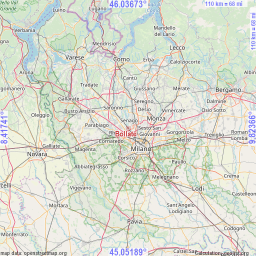
Bollate GPS coordinates[2]
45° 32' 47.292" North, 9° 7' 13.944" East
| Map corner | latitude | longitude |
|---|---|---|
| Upper-left | 46.03673°, | 8.41741° |
| Center: | 45.54647°, | 9.12054° |
| Lower-right: | 45.05189°, | 9.82366° |
| Map W x H: | 109.5×109.5 km | = 68×68mi |
| max Lat: | 47.04031° ⇑24.8% North |
| Bollate: | 45.54647° |
| min Lat: | ⇓75.2% South 35.50142° |
| min Long | Bollate | max Long |
| 6.69888° | 9.12054° | 18.48682° |
| W 20.7%⇐ | ⇒79.3% E |
Elevation
Elevation of Bollate is 155 m = 509 ft, and this is 151.7 m = 498 ft below average elevation for this country.
| Max E: |
2085 m = 6841 ft | 61% |
| Avg. | 306.7 m = 1006 ft | |
| Bollate | 155 m = 509 ft | |
Min E: |
-4 m = -13 ft | 39% |
See also: Italy elevation on elevation.city.
Geographical zone
Bollate is located in North temperate zone (between Tropic of Cancer and the Arctic Circle). Distance of this North polar circle is 2336.9 km =1452.1 mi to North.| Distance of | km | miles | from Bollate |
|---|---|---|---|
| North Pole | 4942.8 | 3071.3 | to North |
| Arctic Circle | 2336.9 | 1452.1 | to North |
| Tropic Cancer | 2458.4 | 1527.6 | to South |
| Equator | 5064.3 | 3146.8 | to South |


Nearby cities:
15 places around Bollate: (largest is in red/bold)
• Arese
3.4 km =2.1 mi,  277°
277°
• Baranzate
2.2 km =1.4 mi,  186°
186°
• Bresso
5.4 km =3.4 mi,  100°
100°
• Campo dei Fiori
6.2 km =3.9 mi,  85°
85°
• Cesate
6.5 km =4 mi,  327°
327°
• Cormano
3.1 km =1.9 mi,  84°
84°
• Cusano
5 km =3.1 mi, 83°
• Garbagnate Milanese
4.7 km =2.9 mi,  311°
311°
• Limbiate
5.9 km =3.7 mi,  3°
3°
• Novate Milanese
2.3 km =1.4 mi,  140°
140°
• Paderno Dugnano
4.3 km =2.7 mi,  54°
54°
• Passirana
6 km =3.7 mi,  271°
271°
• Pero
4.8 km =3 mi,  212°
212°
• Rho
6.4 km =4 mi,  256°
256°
• Senago
3.3 km =2.1 mi,  7°
7°
Sources, notices
• [Note1] Compared only with cities in Italy existing in our database
• [Src1] Map data: © OpenStreetMap contributors (CC-BY-SA)
• [Src2] Other city data from geonames.org with taken over terms of usage.
• [Src3] Geographical zone / Annual Mean Temperature by Robert A. Rohde @ Wikipedia
