Villaverla geodata
Villaverla (Veneto) is a seat of a third-order administrative division; located in Italy in Europe/Rome (GMT+2) time zone. With population of 4,391 people, there are 2194 cities with bigger population in this country. Compared to other cities in Italy, 79% of cities are located further ↓South; 50.7% of cities are located further →East and 75.6% of cities have higher elevation than Villaverla. Note1


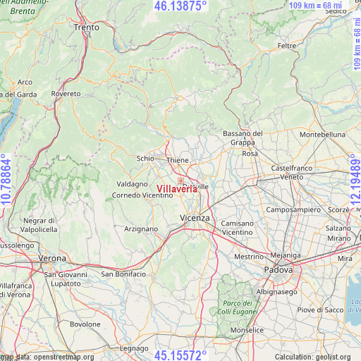
Villaverla GPS coordinates[2]
45° 38' 57.804" North, 11° 29' 30.336" East
| Map corner | latitude | longitude |
|---|---|---|
| Upper-left | 46.13875°, | 10.78864° |
| Center: | 45.64939°, | 11.49176° |
| Lower-right: | 45.15572°, | 12.19489° |
| Map W x H: | 109.3×109.3 km | = 67.9×67.9mi |
| max Lat: | 47.04031° ⇑21% North |
| Villaverla: | 45.64939° |
| min Lat: | ⇓79% South 35.50142° |
| min Long | Villaverla | max Long |
| 6.69888° | 11.49176° | 18.48682° |
| W 49.3%⇐ | ⇒50.7% E |
Elevation
Elevation of Villaverla is 71 m = 233 ft, and this is 235.7 m = 773 ft below average elevation for this country.
| Max E: |
2085 m = 6841 ft | 75.6% |
| Avg. | 306.7 m = 1006 ft | |
| Villaverla | 71 m = 233 ft | |
Min E: |
-4 m = -13 ft | 24.4% |
See also: Italy elevation on elevation.city.
Geographical zone
Villaverla is located in North temperate zone (between Tropic of Cancer and the Arctic Circle). Distance of this North polar circle is 2325.4 km =1444.9 mi to North.| Distance of | km | miles | from Villaverla |
|---|---|---|---|
| North Pole | 4931.3 | 3064.2 | to North |
| Arctic Circle | 2325.4 | 1444.9 | to North |
| Tropic Cancer | 2469.8 | 1534.7 | to South |
| Equator | 5075.7 | 3153.9 | to South |


Nearby cities:
15 places around Villaverla: (largest is in red/bold)
• Caldogno-Rettorgole-Cresole
4.7 km =2.9 mi,  169°
169°
• Castelnovo
4.5 km =2.8 mi,  213°
213°
• Dueville
4.9 km =3 mi,  108°
108°
• Isola Vicentina
4.2 km =2.6 mi,  237°
237°
• Levà
3.7 km =2.3 mi,  59°
59°
• Malo
6 km =3.7 mi,  280°
280°
• Marano Vicentino
6.9 km =4.3 mi,  318°
318°
• Montecchio Precalcino
5.9 km =3.7 mi,  72°
72°
• Motta
6 km =3.7 mi,  175°
175°
• Novoledo
1.4 km =0.9 mi,  103°
103°
• Preara-Moraro-Levà Nord
5.2 km =3.2 mi,  49°
49°
• Rozzampia
3.4 km =2.1 mi,  13°
13°
• Santo
2.8 km =1.7 mi,  352°
352°
• Sarcedo
6.5 km =4 mi,  26°
26°
• Thiene
6.7 km =4.2 mi, 351°
Sources, notices
• [Note1] Compared only with cities in Italy existing in our database
• [Src1] Map data: © OpenStreetMap contributors (CC-BY-SA)
• [Src2] Other city data from geonames.org with taken over terms of usage.
• [Src3] Geographical zone / Annual Mean Temperature by Robert A. Rohde @ Wikipedia
