Feltre geodata
Feltre (Veneto) is a seat of a third-order administrative division; located in Italy in Europe/Rome (GMT+2) time zone. With population of 13,643 people, there are 670 cities with bigger population in this country. Compared to other cities in Italy, 92.4% of cities are located further ↓South; 54.6% of cities are located further ←West and 56.5% of cities have lower elevation than Feltre. Note1


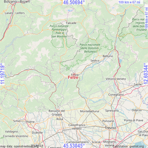
Feltre GPS coordinates[2]
46° 1' 15.06" North, 11° 54' 1.116" East
| Map corner | latitude | longitude |
|---|---|---|
| Upper-left | 46.50694°, | 11.19719° |
| Center: | 46.02085°, | 11.90031° |
| Lower-right: | 45.53045°, | 12.60344° |
| Map W x H: | 108.6×108.6 km | = 67.5×67.5mi |
| max Lat: | 47.04031° ⇑7.6% North |
| Feltre: | 46.02085° |
| min Lat: | ⇓92.4% South 35.50142° |
| min Long | Feltre | max Long |
| 6.69888° | 11.90031° | 18.48682° |
| W 54.6%⇐ | ⇒45.4% E |
Elevation
Elevation of Feltre is 275 m = 902 ft, and this is 31.7 m = 104 ft below average elevation for this country.
| Max E: |
2085 m = 6841 ft | 43.5% |
| Avg. | 306.7 m = 1006 ft | |
| Feltre | 275 m = 902 ft | |
Min E: |
-4 m = -13 ft | 56.5% |
See also: Italy elevation on elevation.city.
Geographical zone
Feltre is located in North temperate zone (between Tropic of Cancer and the Arctic Circle). Distance of this North polar circle is 2284.1 km =1419.3 mi to North.| Distance of | km | miles | from Feltre |
|---|---|---|---|
| North Pole | 4890 | 3038.5 | to North |
| Arctic Circle | 2284.1 | 1419.3 | to North |
| Tropic Cancer | 2511.1 | 1560.3 | to South |
| Equator | 5117 | 3179.6 | to South |


Nearby cities:
15 places around Feltre: (largest is in red/bold)
• Anzù
2.9 km =1.8 mi,  117°
117°
• Arten
5.7 km =3.5 mi,  255°
255°
• Cesiomaggiore
9.8 km =6.1 mi,  41°
41°
• Facen-Travagola
3 km =1.9 mi,  287°
287°
• Foen
2.4 km =1.5 mi,  17°
17°
• Fonzaso
7.8 km =4.8 mi,  266°
266°
• Lentiai
9.7 km =6 mi,  73°
73°
• Pedavena
2.5 km =1.6 mi,  327°
327°
• Quero
11.4 km =7.1 mi,  167°
167°
• Seren del Grappa
4.4 km =2.7 mi,  230°
230°
• Servo
9.7 km =6 mi,  295°
295°
• Sovramonte
9.7 km =6 mi, 295°
• Vas
9.6 km =6 mi,  163°
163°
• Villabruna-Umin
4.5 km =2.8 mi,  27°
27°
• Villapiana-Ronchena
7.8 km =4.8 mi,  79°
79°
Sources, notices
• [Note1] Compared only with cities in Italy existing in our database
• [Src1] Map data: © OpenStreetMap contributors (CC-BY-SA)
• [Src2] Other city data from geonames.org with taken over terms of usage.
• [Src3] Geographical zone / Annual Mean Temperature by Robert A. Rohde @ Wikipedia
