Cigole geodata
Cigole (Lombardy) is a seat of a third-order administrative division; located in Italy in Europe/Rome (GMT+2) time zone. With population of 1,533 people, there are 5048 cities with bigger population in this country. Compared to other cities in Italy, 67.6% of cities are located further ↓South; 66.1% of cities are located further →East and 78.5% of cities have higher elevation than Cigole. Note1


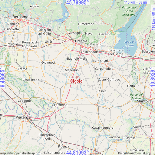
Cigole GPS coordinates[2]
45° 18' 27.36" North, 10° 11' 23.172" East
| Map corner | latitude | longitude |
|---|---|---|
| Upper-left | 45.79995°, | 9.48665° |
| Center: | 45.3076°, | 10.18977° |
| Lower-right: | 44.81093°, | 10.8929° |
| Map W x H: | 110×110 km | = 68.4×68.4mi |
| max Lat: | 47.04031° ⇑32.4% North |
| Cigole: | 45.3076° |
| min Lat: | ⇓67.6% South 35.50142° |
| min Long | Cigole | max Long |
| 6.69888° | 10.18977° | 18.48682° |
| W 33.9%⇐ | ⇒66.1% E |
Elevation
Elevation of Cigole is 57 m = 187 ft, and this is 249.7 m = 819 ft below average elevation for this country.
| Max E: |
2085 m = 6841 ft | 78.5% |
| Avg. | 306.7 m = 1006 ft | |
| Cigole | 57 m = 187 ft | |
Min E: |
-4 m = -13 ft | 21.5% |
See also: Italy elevation on elevation.city.
Geographical zone
Cigole is located in North temperate zone (between Tropic of Cancer and the Arctic Circle). Distance of this North polar circle is 2363.4 km =1468.5 mi to North.| Distance of | km | miles | from Cigole |
|---|---|---|---|
| North Pole | 4969.3 | 3087.8 | to North |
| Arctic Circle | 2363.4 | 1468.5 | to North |
| Tropic Cancer | 2431.8 | 1511 | to South |
| Equator | 5037.7 | 3130.3 | to South |


Nearby cities:
15 places around Cigole: (largest is in red/bold)
• Alfianello
5.6 km =3.5 mi,  215°
215°
• Bassano Bresciano
5.3 km =3.3 mi,  295°
295°
• Castelletto
4.3 km =2.7 mi,  52°
52°
• Cignano
9.8 km =6.1 mi,  317°
317°
• Gottolengo
6.4 km =4 mi,  104°
104°
• Leno
7.2 km =4.5 mi,  17°
17°
• Manerbio
6.5 km =4 mi, 321°
• Milzano
3.9 km =2.4 mi,  168°
168°
• Pavone del Mella
1.7 km =1.1 mi,  113°
113°
• Pontevico
8.5 km =5.3 mi,  243°
243°
• Pralboino
5 km =3.1 mi,  153°
153°
• San Gervasio Bresciano
3.4 km =2.1 mi,  270°
270°
• Scandolara Ripa d'Oglio
9.9 km =6.2 mi,  194°
194°
• Seniga
7 km =4.3 mi, 187°
• Verolanuova
9 km =5.6 mi,  284°
284°
Sources, notices
• [Note1] Compared only with cities in Italy existing in our database
• [Src1] Map data: © OpenStreetMap contributors (CC-BY-SA)
• [Src2] Other city data from geonames.org with taken over terms of usage.
• [Src3] Geographical zone / Annual Mean Temperature by Robert A. Rohde @ Wikipedia
