Gottolengo geodata
Gottolengo (Lombardy) is a seat of a third-order administrative division; located in Italy in Europe/Rome (GMT+2) time zone. With population of 4,456 people, there are 2166 cities with bigger population in this country. Compared to other cities in Italy, 67.3% of cities are located further ↓South; 65.4% of cities are located further →East and 79.7% of cities have higher elevation than Gottolengo. Note1


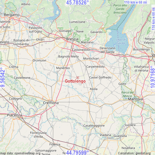
Gottolengo GPS coordinates[2]
45° 17' 34.008" North, 10° 16' 6.78" East
| Map corner | latitude | longitude |
|---|---|---|
| Upper-left | 45.78526°, | 9.56542° |
| Center: | 45.29278°, | 10.26855° |
| Lower-right: | 44.79599°, | 10.97168° |
| Map W x H: | 110×110 km | = 68.4×68.4mi |
| max Lat: | 47.04031° ⇑32.7% North |
| Gottolengo: | 45.29278° |
| min Lat: | ⇓67.3% South 35.50142° |
| min Long | Gottolengo | max Long |
| 6.69888° | 10.26855° | 18.48682° |
| W 34.6%⇐ | ⇒65.4% E |
Elevation
Elevation of Gottolengo is 51 m = 167 ft, and this is 255.7 m = 839 ft below average elevation for this country.
| Max E: |
2085 m = 6841 ft | 79.7% |
| Avg. | 306.7 m = 1006 ft | |
| Gottolengo | 51 m = 167 ft | |
Min E: |
-4 m = -13 ft | 20.3% |
See also: Italy elevation on elevation.city.
Geographical zone
Gottolengo is located in North temperate zone (between Tropic of Cancer and the Arctic Circle). Distance of this North polar circle is 2365.1 km =1469.6 mi to North.| Distance of | km | miles | from Gottolengo |
|---|---|---|---|
| North Pole | 4971 | 3088.8 | to North |
| Arctic Circle | 2365.1 | 1469.6 | to North |
| Tropic Cancer | 2430.2 | 1510.1 | to South |
| Equator | 5036.1 | 3129.3 | to South |


Nearby cities:
15 places around Gottolengo: (largest is in red/bold)
• Calvisano
8.2 km =5.1 mi,  44°
44°
• Castelletto
5.1 km =3.2 mi,  327°
327°
• Cigole
6.4 km =4 mi,  284°
284°
• Fiesse
8 km =5 mi,  147°
147°
• Gabbioneta
9.3 km =5.8 mi,  203°
203°
• Gambara
4.8 km =3 mi,  155°
155°
• Isorella
4.6 km =2.9 mi,  66°
66°
• Milzano
5.8 km =3.6 mi,  248°
248°
• Ostiano
7.9 km =4.9 mi,  188°
188°
• Pavone del Mella
4.7 km =2.9 mi, 281°
• Pralboino
4.8 km =3 mi,  234°
234°
• Remedello
8.2 km =5.1 mi,  101°
101°
• Remedello di Sopra
8.2 km =5.1 mi, 101°
• Seniga
8.9 km =5.5 mi, 233°
• Visano
8.4 km =5.2 mi, 71°
Sources, notices
• [Note1] Compared only with cities in Italy existing in our database
• [Src1] Map data: © OpenStreetMap contributors (CC-BY-SA)
• [Src2] Other city data from geonames.org with taken over terms of usage.
• [Src3] Geographical zone / Annual Mean Temperature by Robert A. Rohde @ Wikipedia
