Leini geodata
Leini (Piedmont) is a seat of a third-order administrative division; located in Italy in Europe/Rome (GMT+2) time zone. With population of 13,644 people, there are 668 cities with bigger population in this country. Compared to other cities in Italy, 64.5% of cities are located further ↓South; 96.2% of cities are located further →East and 52.5% of cities have lower elevation than Leini. Note1


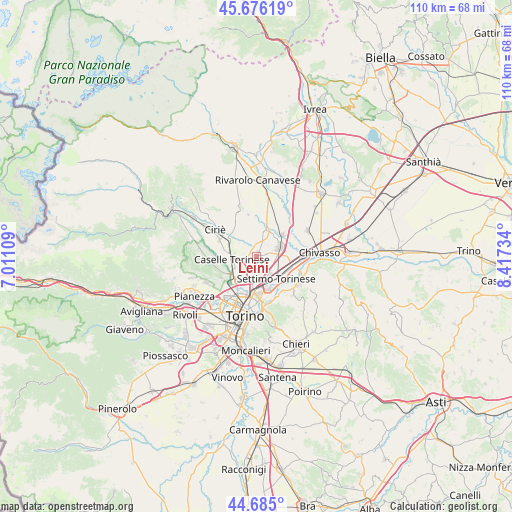
Leini GPS coordinates[2]
45° 10' 57.9" North, 7° 42' 51.192" East
| Map corner | latitude | longitude |
|---|---|---|
| Upper-left | 45.67619°, | 7.01109° |
| Center: | 45.18275°, | 7.71422° |
| Lower-right: | 44.685°, | 8.41734° |
| Map W x H: | 110.2×110.2 km | = 68.5×68.5mi |
| max Lat: | 47.04031° ⇑35.5% North |
| Leini: | 45.18275° |
| min Lat: | ⇓64.5% South 35.50142° |
| min Long | Leini | max Long |
| 6.69888° | 7.71422° | 18.48682° |
| W 3.8%⇐ | ⇒96.2% E |
Elevation
Elevation of Leini is 250 m = 820 ft, and this is 56.7 m = 186 ft below average elevation for this country.
| Max E: |
2085 m = 6841 ft | 47.5% |
| Avg. | 306.7 m = 1006 ft | |
| Leini | 250 m = 820 ft | |
Min E: |
-4 m = -13 ft | 52.5% |
See also: Italy elevation on elevation.city.
Geographical zone
Leini is located in North temperate zone (between Tropic of Cancer and the Arctic Circle). Distance of this North polar circle is 2377.3 km =1477.2 mi to North.| Distance of | km | miles | from Leini |
|---|---|---|---|
| North Pole | 4983.2 | 3096.4 | to North |
| Arctic Circle | 2377.3 | 1477.2 | to North |
| Tropic Cancer | 2417.9 | 1502.4 | to South |
| Equator | 5023.9 | 3121.7 | to South |


Nearby cities:
15 places around Leini: (largest is in red/bold)
• Borgaro Torinese
5.8 km =3.6 mi,  232°
232°
• Brandizzo
9.6 km =6 mi,  93°
93°
• Caselle Torinese
5.7 km =3.5 mi,  260°
260°
• Lombardore
6.2 km =3.9 mi,  16°
16°
• Malanghero
4.5 km =2.8 mi,  295°
295°
• Mappano
3.9 km =2.4 mi,  187°
187°
• Olimpia
6.5 km =4 mi,  168°
168°
• Rivarossa
7.4 km =4.6 mi,  3°
3°
• San Benigno Canavese
7.3 km =4.5 mi,  48°
48°
• San Francesco al Campo
6.8 km =4.2 mi,  316°
316°
• San Maurizio
7.6 km =4.7 mi, 300°
• San Mauro Torinese
9.8 km =6.1 mi,  154°
154°
• Settimo Torinese
6.5 km =4 mi,  137°
137°
• Venaria Reale
9.1 km =5.7 mi, 225°
• Volpiano
5.1 km =3.2 mi,  68°
68°
Sources, notices
• [Note1] Compared only with cities in Italy existing in our database
• [Src1] Map data: © OpenStreetMap contributors (CC-BY-SA)
• [Src2] Other city data from geonames.org with taken over terms of usage.
• [Src3] Geographical zone / Annual Mean Temperature by Robert A. Rohde @ Wikipedia
