Rivarossa geodata
Rivarossa (Piedmont) is a seat of a third-order administrative division; located in Italy in Europe/Rome (GMT+2) time zone. With population of 919 people, there are 7032 cities with bigger population in this country. Compared to other cities in Italy, 66.2% of cities are located further ↓South; 96.2% of cities are located further →East and 51.7% of cities have lower elevation than Rivarossa. Note1


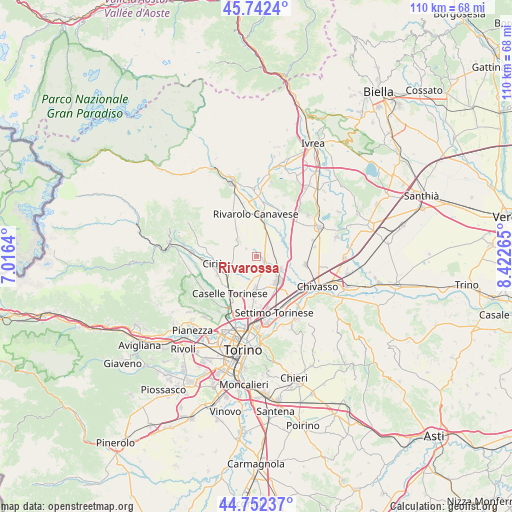
Rivarossa GPS coordinates[2]
45° 14' 58.344" North, 7° 43' 10.308" East
| Map corner | latitude | longitude |
|---|---|---|
| Upper-left | 45.7424°, | 7.0164° |
| Center: | 45.24954°, | 7.71953° |
| Lower-right: | 44.75237°, | 8.42265° |
| Map W x H: | 110.1×110.1 km | = 68.4×68.4mi |
| max Lat: | 47.04031° ⇑33.8% North |
| Rivarossa: | 45.24954° |
| min Lat: | ⇓66.2% South 35.50142° |
| min Long | Rivarossa | max Long |
| 6.69888° | 7.71953° | 18.48682° |
| W 3.8%⇐ | ⇒96.2% E |
Elevation
Elevation of Rivarossa is 245 m = 804 ft, and this is 61.7 m = 202 ft below average elevation for this country.
| Max E: |
2085 m = 6841 ft | 48.3% |
| Avg. | 306.7 m = 1006 ft | |
| Rivarossa | 245 m = 804 ft | |
Min E: |
-4 m = -13 ft | 51.7% |
See also: Italy elevation on elevation.city.
Geographical zone
Rivarossa is located in North temperate zone (between Tropic of Cancer and the Arctic Circle). Distance of this North polar circle is 2369.9 km =1472.6 mi to North.| Distance of | km | miles | from Rivarossa |
|---|---|---|---|
| North Pole | 4975.8 | 3091.8 | to North |
| Arctic Circle | 2369.9 | 1472.6 | to North |
| Tropic Cancer | 2425.4 | 1507.1 | to South |
| Equator | 5031.3 | 3126.3 | to South |


Nearby cities:
15 places around Rivarossa: (largest is in red/bold)
• Barbania
8.1 km =5 mi,  304°
304°
• Bosconero
4.1 km =2.5 mi,  62°
62°
• Feletto
6.3 km =3.9 mi,  18°
18°
• Foglizzo
8.4 km =5.2 mi,  71°
71°
• Front
5.5 km =3.4 mi,  307°
307°
• Leini
7.4 km =4.6 mi,  183°
183°
• Lombardore
2.1 km =1.3 mi,  138°
138°
• Lusigliè
8.4 km =5.2 mi, 24°
• Malanghero
7.1 km =4.4 mi,  219°
219°
• Rivarolo Canavese
8.8 km =5.5 mi,  0°
0°
• San Benigno Canavese
5.7 km =3.5 mi,  117°
117°
• San Francesco al Campo
5.6 km =3.5 mi,  244°
244°
• San Maurizio
7.9 km =4.9 mi, 242°
• Vauda Canavese Superiore
8.5 km =5.3 mi,  293°
293°
• Volpiano
7.1 km =4.4 mi, 141°
Sources, notices
• [Note1] Compared only with cities in Italy existing in our database
• [Src1] Map data: © OpenStreetMap contributors (CC-BY-SA)
• [Src2] Other city data from geonames.org with taken over terms of usage.
• [Src3] Geographical zone / Annual Mean Temperature by Robert A. Rohde @ Wikipedia
